IMAGES TAKEN NEAR TO
Perceton, IRVINE, KA11 2FX
Introduction
This page details the photographs taken nearby to KA11 2FX by members of the Geograph project.
The Geograph project started in 2005 with the aim of publishing, organising and preserving representative images for every square kilometre of Great Britain, Ireland and the Isle of Man.

There are currently over 7.5m images from over14,400 individuals and you can help contribute to the project by visiting https://www.geograph.org.uk
Image Map (Loading...)


Getting Data...Please wait
Leaflet Map data © OpenStreetMap
Images are licensed for reuse under creativecommons.org/licenses/by-sa/2.0
Notes
- Clicking on the map will re-center to the selected point.
- The higher the marker number, the further away the image location is from the centre of the postcode.
Image Listing (5 Images Found)
Images are licensed for reuse under creativecommons.org/licenses/by-sa/2.0
Image
Details
Distance
2
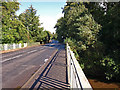
Old Perceton
Viewed from Perceton roundabout.
Image: © wfmillar
Taken: 14 Sep 2010
0.08 miles
5
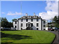
Perceton House
Now one of North Ayrshire Councils buildings. In the early 14th century the land became the principal residence of a member of the Stewart family. The old stockade was removed and a moat excavated, probably around a new manor house. In the late 1400s following a period of absorption in larger estates the site again became a principal residence, to one Ninian Barclay. This resulted in the building of a new mansion which was demolished in the 1720s, when another new owner constructed the present Perceton House.
Image: © Ian Rainey
Taken: 23 May 2006
0.19 miles