IMAGES TAKEN NEAR TO
Earlswood Way, IRVINE, KA11 2FB
Introduction
This page details the photographs taken nearby to Earlswood Way, KA11 2FB by members of the Geograph project.
The Geograph project started in 2005 with the aim of publishing, organising and preserving representative images for every square kilometre of Great Britain, Ireland and the Isle of Man.

There are currently over 7.5m images from over14,400 individuals and you can help contribute to the project by visiting https://www.geograph.org.uk
Image Map
Images are licensed for reuse under creativecommons.org/licenses/by-sa/2.0
Notes
- Clicking on the map will re-center to the selected point.
- The higher the marker number, the further away the image location is from the centre of the postcode.
Image Listing (15 Images Found)
Images are licensed for reuse under creativecommons.org/licenses/by-sa/2.0
Image
Details
Distance
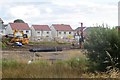
1
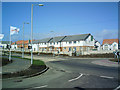
New Private Housing Estate
Earlswood Private Housing Estate adds to the ever expanding Irvine New Town. So new in fact that it doesn't show on the maps yet
Image: © Ian Rainey
Taken: 29 Mar 2006
0.04 miles
3
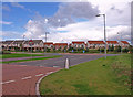
Earlswood Housing Estate, Irvine
Ever expanding New Town.
Image: © wfmillar
Taken: 15 Sep 2010
0.09 miles
4
Regalia View
New residential area in Irvine.
Image: © Richard Webb
Taken: 1 Sep 2015
0.09 miles
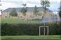
5
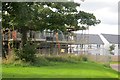
Housebuilding, Irvine
Next to, but not on Earlswood Drive.
Image: © Richard Webb
Taken: 1 Sep 2015
0.10 miles
6
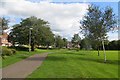
Path, Irvine
A path from Earlswood Wynd to Stanecastle.
Image: © Richard Webb
Taken: 1 Sep 2015
0.10 miles
7
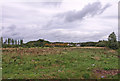
Undeveloped Land near Sourlie
I expect it will soon be built up as there are housing developments all around this area.
Image: © wfmillar
Taken: 15 Sep 2010
0.10 miles
8
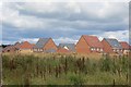
New houses, Irvine
A big chunk of land between the A736 and A78 is being developed for housing.
Image: © Richard Webb
Taken: 1 Sep 2015
0.14 miles
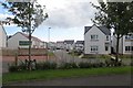
9
House building, Irvine
Looking into the active construction area from currently unused land.
Image: © Richard Webb
Taken: 1 Sep 2015
0.14 miles
10
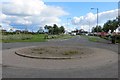
Road end
The current end of the road is marked with a roundabout. This is an actively developed piece of land and soon roads will branch off here to new houses.
Image: © Richard Webb
Taken: 1 Sep 2015
0.15 miles