IMAGES TAKEN NEAR TO
Chestnut Gardens, IRVINE, KA11 1RW
Introduction
This page details the photographs taken nearby to Chestnut Gardens, KA11 1RW by members of the Geograph project.
The Geograph project started in 2005 with the aim of publishing, organising and preserving representative images for every square kilometre of Great Britain, Ireland and the Isle of Man.

There are currently over 7.5m images from over14,400 individuals and you can help contribute to the project by visiting https://www.geograph.org.uk
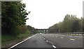
Image Map
Images are licensed for reuse under creativecommons.org/licenses/by-sa/2.0
Notes
- Clicking on the map will re-center to the selected point.
- The higher the marker number, the further away the image location is from the centre of the postcode.
Image Listing (12 Images Found)
Images are licensed for reuse under creativecommons.org/licenses/by-sa/2.0
Image
Details
Distance
1
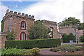
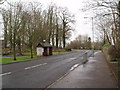
Stanecastle Gate
Ex Gamekeepers residence and the southern gatehouse entrance to Eglinton Castle.
Image: © wfmillar
Taken: 15 Sep 2010
0.17 miles
4
Brick Bus Shelter
Bus shelter on Stotfield Road in the Stanefield area of Irvine New Town. Brick built shelters are rare in the area. 8th April 2010 9.10am.
Image: © Gordon Dowie
Taken: 8 Apr 2010
0.20 miles
5
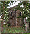
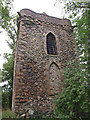
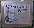
Stanecastle Keep
Part of Eglington Estate, Irvine.Image
Image: © wfmillar
Taken: 15 Sep 2010
0.21 miles
6
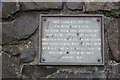
Irvine Burns Club cairn
The cairn is beside the A78 and carries a plaque Image, which was resited by the road builders.
"This cairn was erected
for Irvine Burns Club
to mark their 150th anniversary
and to relocate the plaque
originally placed at the Drunken Steps
700 yards northwest of this spot
by W. & C. French (construction) ltd.
Builders of Irvine Bypass January 1976"
Image: © Richard Webb
Taken: 1 Sep 2015
0.24 miles
7
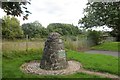
Irvine Burns Club cairn
Carries a relocated cairn, moved when the A78 Irvine bypass was built through the original site.
The plaque text:
"Eglinton Woods Drunken Steps St Brides Well
Favourite walk(1781-82) of Robert Burns
and his sailor friend
Richard Brown
Do you recollect a Sunday we spent together in Eglinton Woods? RB
Irvine Burns Club Edinburgh
25th January 1927 30th Dec 1787"
Image: © Richard Webb
Taken: 1 Sep 2015
0.24 miles
9
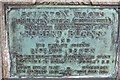
Drunken Steps plaque
The plaque was moved and placed on a cairn when the original site fell victim to the construction of the A78 Irvine bypass.
"Eglinton Woods Drunken Steps St Brides Well
Favourite walk(1781-82) of Robert Burns
and his sailor friend
Richard Brown
Do you recollect a Sunday we spent together in Eglinton Woods? RB
Irvine Burns Club Edinburgh
25th January 1927 30th Dec 1787"
Image: © Richard Webb
Taken: 1 Sep 2015
0.24 miles