IMAGES TAKEN NEAR TO
Kames Court, IRVINE, KA11 1RT
Introduction
This page details the photographs taken nearby to Kames Court, KA11 1RT by members of the Geograph project.
The Geograph project started in 2005 with the aim of publishing, organising and preserving representative images for every square kilometre of Great Britain, Ireland and the Isle of Man.

There are currently over 7.5m images from over14,400 individuals and you can help contribute to the project by visiting https://www.geograph.org.uk
Image Map
Images are licensed for reuse under creativecommons.org/licenses/by-sa/2.0
Notes
- Clicking on the map will re-center to the selected point.
- The higher the marker number, the further away the image location is from the centre of the postcode.
Image Listing (6 Images Found)
Images are licensed for reuse under creativecommons.org/licenses/by-sa/2.0
Image
Details
Distance
4
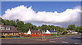
Old Perceton
Viewed from Perceton roundabout.
Image: © wfmillar
Taken: 14 Sep 2010
0.17 miles
5
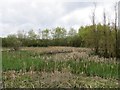
Wetland, Lawthorn
A vegetated pond beside a long disused railway.
Image: © Richard Webb
Taken: 25 Apr 2014
0.22 miles