IMAGES TAKEN NEAR TO
West Bowhouse Way, IRVINE, KA11 1NL
Introduction
This page details the photographs taken nearby to West Bowhouse Way, KA11 1NL by members of the Geograph project.
The Geograph project started in 2005 with the aim of publishing, organising and preserving representative images for every square kilometre of Great Britain, Ireland and the Isle of Man.

There are currently over 7.5m images from over14,400 individuals and you can help contribute to the project by visiting https://www.geograph.org.uk
Image Map
Images are licensed for reuse under creativecommons.org/licenses/by-sa/2.0
Notes
- Clicking on the map will re-center to the selected point.
- The higher the marker number, the further away the image location is from the centre of the postcode.
Image Listing (2 Images Found)
Images are licensed for reuse under creativecommons.org/licenses/by-sa/2.0
Image
Details
Distance
1
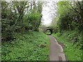
Railway trackbed, Irvine
A former mineral line at Girdle Toll. It served the Perceton Colliery and is shown as disused on maps around 1900.
Image: © Richard Webb
Taken: 25 Apr 2014
0.04 miles
2
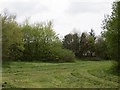
A new town park
Typical new town scenery, mown grass and young plantations, houses rarely out of sight.
Image: © Richard Webb
Taken: 25 Apr 2014
0.24 miles