IMAGES TAKEN NEAR TO
Cramond Way, IRVINE, KA11 1HF
Introduction
This page details the photographs taken nearby to Cramond Way, KA11 1HF by members of the Geograph project.
The Geograph project started in 2005 with the aim of publishing, organising and preserving representative images for every square kilometre of Great Britain, Ireland and the Isle of Man.

There are currently over 7.5m images from over14,400 individuals and you can help contribute to the project by visiting https://www.geograph.org.uk
Image Map
Images are licensed for reuse under creativecommons.org/licenses/by-sa/2.0
Notes
- Clicking on the map will re-center to the selected point.
- The higher the marker number, the further away the image location is from the centre of the postcode.
Image Listing (4 Images Found)
Images are licensed for reuse under creativecommons.org/licenses/by-sa/2.0
Image
Details
Distance
1
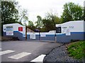
Irvine East Primary School, development site
Image: © Alex McGregor
Taken: 21 May 2013
0.15 miles
2
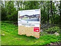
Irvine East Primary School, development site
Image: © Alex McGregor
Taken: 21 May 2013
0.16 miles
3
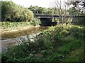
Annick Water
Long Drive crossing the Annick Water.
Image: © Richard Webb
Taken: 9 Sep 2009
0.17 miles
4

Riverside
Area of native trees and grassland on the banks of the Annick Water in Irvine New Town.
Image: © Chris Court
Taken: 18 Feb 2006
0.22 miles