IMAGES TAKEN NEAR TO
Gigha Terrace, IRVINE, KA11 1DJ
Introduction
This page details the photographs taken nearby to Gigha Terrace, KA11 1DJ by members of the Geograph project.
The Geograph project started in 2005 with the aim of publishing, organising and preserving representative images for every square kilometre of Great Britain, Ireland and the Isle of Man.

There are currently over 7.5m images from over14,400 individuals and you can help contribute to the project by visiting https://www.geograph.org.uk
Image Map
Images are licensed for reuse under creativecommons.org/licenses/by-sa/2.0
Notes
- Clicking on the map will re-center to the selected point.
- The higher the marker number, the further away the image location is from the centre of the postcode.
Image Listing (18 Images Found)
Images are licensed for reuse under creativecommons.org/licenses/by-sa/2.0
Image
Details
Distance
1
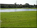
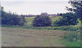
Waterlogged pitch
A recreation park beside the Annick Water. There had been a long period of heavy rain recently and quite a lot of water had yet to drain.
Image: © Richard Webb
Taken: 9 Sep 2009
0.15 miles
2
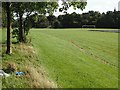
Recreation Ground
Flooded football and litter just off a foot/cyclepath in Irvine. A "tide" line can be seen, suggesting why this land was not built upon.
Image: © Richard Webb
Taken: 9 Sep 2009
0.17 miles
3
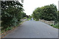
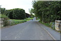
Former railway bridge
This bridge carried the Irvine and Kilmarnock line over the Annick Water. It is now used by National Cycle Network Route 73.
Image: © Richard Webb
Taken: 9 Sep 2009
0.17 miles
4
Site of Dreghorn station, 1994
View SE on Station Brae, towards Crosshouse (to left): ex-G&SWR Irvine - Crosshouse line, all closed 6/4/64.
Image: © Ben Brooksbank
Taken: 21 Jun 1994
0.17 miles
6
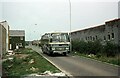
Broomlands Busway, Irvine New Town ? 1976
The new towns of Runcorn and Irvine of the 1970s were the only ones to incorporate dedicated busways into the development. The Irvine examples were less grandiose than those in Runcorn https://www.geograph.org.uk/photo/6726020 , consisting of single lane roads with passing places. This view shows that unlike the majority of housing developments of the late 20th and early 21st centuries, bus services were established before occupation of the houses was complete, ensuring that the new residents had the option of convenient public transport from the outset.
The bus is a Leyland Leopard with Duple coach-style bodywork operated by A1 Service. A1 was a relatively rare example of a consortium of small operators working under a single brand name. Operators' individual bases were spread across the area between Ardrossan and Kilmarnock with a service between these two towns forming the backbone of the operations. The organisation of the consortium was such that not single operator could become a dominant member, and ensured that the operation of services was shared in an equitable manner.
The service pictured here was unusual in being the only one that was not included in the main pool, being specific to the firm of Docherty of Irvine.
This is one of a series of views featuring buses in the 60s, 70s, and 80s. http://www.geograph.org.uk/search.php?i=137652761
Image: © Alan Murray-Rust
Taken: 5 Jan 1976
0.21 miles

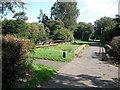
8
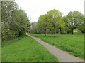
Cycle path, Irvine
Running through parkland.
Image: © Richard Webb
Taken: 25 Apr 2014
0.22 miles