IMAGES TAKEN NEAR TO
Western Gailes Avenue, KA10 7GL
Introduction
This page details the photographs taken nearby to Western Gailes Avenue, KA10 7GL by members of the Geograph project.
The Geograph project started in 2005 with the aim of publishing, organising and preserving representative images for every square kilometre of Great Britain, Ireland and the Isle of Man.

There are currently over 7.5m images from over14,400 individuals and you can help contribute to the project by visiting https://www.geograph.org.uk
Image Map
Images are licensed for reuse under creativecommons.org/licenses/by-sa/2.0
Notes
- Clicking on the map will re-center to the selected point.
- The higher the marker number, the further away the image location is from the centre of the postcode.
Image Listing (8 Images Found)
Images are licensed for reuse under creativecommons.org/licenses/by-sa/2.0
Image
Details
Distance
1
Towards Princess Gate
A closer look at the new house-building site at Muirhead on the other side of the A759. Part of Troon Harbour is in the background with Barassie on the far right. Viewed from the next square on a lovely mid-August day.
Image: © Mary and Angus Hogg
Taken: 24 Aug 2020
0.16 miles
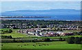
2
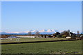
House near Barassie
With a lovely view of Arran, telephoto effect.
Image: © Billy McCrorie
Taken: 2 Feb 2019
0.19 miles

4
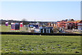
Princess Gate Housing Development, Barassie
Image: © Billy McCrorie
Taken: 2 Feb 2019
0.23 miles
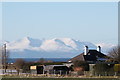
6
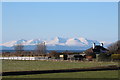
Farmland near Barassie
With a lovely view of Arran.
Image: © Billy McCrorie
Taken: 2 Feb 2019
0.24 miles
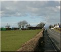
7
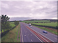
A78 near Collennan
Taken from the minor road flyover looking northwest.
Image: © wfmillar
Taken: 21 Sep 2010
0.24 miles
8
Farmland near Loans
With a view to Arran.
Image: © Billy McCrorie
Taken: 2 Feb 2019
0.25 miles