IMAGES TAKEN NEAR TO
TROON, KA10 7ET
Introduction
This page details the photographs taken nearby to KA10 7ET by members of the Geograph project.
The Geograph project started in 2005 with the aim of publishing, organising and preserving representative images for every square kilometre of Great Britain, Ireland and the Isle of Man.

There are currently over 7.5m images from over14,400 individuals and you can help contribute to the project by visiting https://www.geograph.org.uk
Image Map
Images are licensed for reuse under creativecommons.org/licenses/by-sa/2.0
Notes
- Clicking on the map will re-center to the selected point.
- The higher the marker number, the further away the image location is from the centre of the postcode.
Image Listing (12 Images Found)
Images are licensed for reuse under creativecommons.org/licenses/by-sa/2.0
Image
Details
Distance
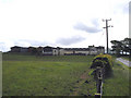
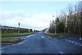
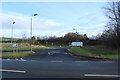
3
Looking towards the A79 Flyover
From minor road near Southside Farm.
Image: © wfmillar
Taken: 21 Sep 2010
0.20 miles
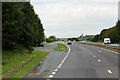
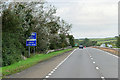
6
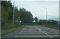
Go slower lines on the road
Approaching a traffic island with the ubiquitous yellow stripes to make it appear, to drivers, that they are going faster than they are. This is so that they slow down quicker as they approach the island and hopefully improve road safety.
Image: © Malcolm Neal
Taken: 20 Sep 2022
0.22 miles