IMAGES TAKEN NEAR TO
Mossgiel Avenue, TROON, KA10 7DQ
Introduction
This page details the photographs taken nearby to Mossgiel Avenue, KA10 7DQ by members of the Geograph project.
The Geograph project started in 2005 with the aim of publishing, organising and preserving representative images for every square kilometre of Great Britain, Ireland and the Isle of Man.

There are currently over 7.5m images from over14,400 individuals and you can help contribute to the project by visiting https://www.geograph.org.uk
Image Map
Images are licensed for reuse under creativecommons.org/licenses/by-sa/2.0
Notes
- Clicking on the map will re-center to the selected point.
- The higher the marker number, the further away the image location is from the centre of the postcode.
Image Listing (4 Images Found)
Images are licensed for reuse under creativecommons.org/licenses/by-sa/2.0
Image
Details
Distance
2
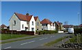
Merrick Avenue, Troon
Housing area viewed on a lovely spring afternoon.
Image: © Mary and Angus Hogg
Taken: 21 Apr 2016
0.08 miles
3
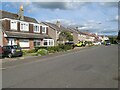
North Drive
On the edge of Troon, in the Muirhead district. The road continues as a traffic-free route to Loans.
Image: © Jonathan Wilkins
Taken: 12 Sep 2023
0.10 miles
4
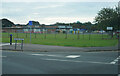
Muirhead Primary School
Looking across Buchan Road towards Muirhead Primary School.
Image: © Malcolm Neal
Taken: 20 Sep 2022
0.23 miles