IMAGES TAKEN NEAR TO
Auchengate, TROON, KA10 6UG
Introduction
This page details the photographs taken nearby to Auchengate, KA10 6UG by members of the Geograph project.
The Geograph project started in 2005 with the aim of publishing, organising and preserving representative images for every square kilometre of Great Britain, Ireland and the Isle of Man.

There are currently over 7.5m images from over14,400 individuals and you can help contribute to the project by visiting https://www.geograph.org.uk
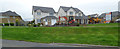
Image Map
Images are licensed for reuse under creativecommons.org/licenses/by-sa/2.0
Notes
- Clicking on the map will re-center to the selected point.
- The higher the marker number, the further away the image location is from the centre of the postcode.
Image Listing (19 Images Found)
Images are licensed for reuse under creativecommons.org/licenses/by-sa/2.0
Image
Details
Distance
1
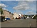
Cycle route 7, Auchengate
Part of a complex and extensive housing estate, where cycle route 7 finds its way out of Barassie.
Image: © Jonathan Wilkins
Taken: 12 Sep 2023
0.01 miles
2
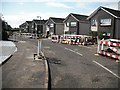
Citadel Way
Residential street with utilities work in progress, Barassie.
Image: © Richard Webb
Taken: 9 Sep 2009
0.08 miles
3
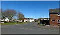
Lochgreen Avenue, Barassie
Suburban housing area viewed on a lovely mid-March afternoon.
Image: © Mary and Angus Hogg
Taken: 21 Apr 2016
0.10 miles
4
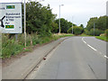
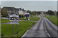
The A759 road
The signposted roundabout and the one beyond enable limited access to the A78 dual carriageway (southbound access, northbound exit).
Image: © Thomas Nugent
Taken: 6 Aug 2018
0.12 miles
5
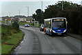
Number 14 to Irvine
Stagecoach Western Scotland 36741, ADL Enviro 200 (SF62 CYS) on the A759 near Barassie. It is on route number 14, from Ayr to Irvine.
Image: © David Dixon
Taken: 25 Sep 2019
0.12 miles
6
Earl's Green
New residential development off Kilmarnock Road, on the outskirts of Troon.
Image: © David Dixon
Taken: 25 Sep 2019
0.14 miles
7
The B746 facing NE
At the very north end of Troon the B746 leads NW inland from the shore.
Image: © Malcolm Neal
Taken: 8 May 2018
0.15 miles
8
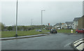
Kilmarnock Road
Joining the A759 and thereby the main roads network.
Image: © Thomas Nugent
Taken: 6 Aug 2018
0.15 miles
9
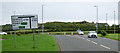
Housing development off Kilmarnock Road
Earls Green, by Bellway Homes https://www.bellway.co.uk/new-homes/scotland-west/earls-green .
Image: © Thomas Nugent
Taken: 6 Aug 2018
0.15 miles
10
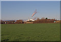
Field , Barassie
Looking towards the A78 with the Irvine paper mill making steam. The hills in the distance are at Muirshiel Country park.
Image: © wfmillar
Taken: 30 Nov 2009
0.15 miles