IMAGES TAKEN NEAR TO
Ailsa Road, TROON, KA10 6DB
Introduction
This page details the photographs taken nearby to Ailsa Road, KA10 6DB by members of the Geograph project.
The Geograph project started in 2005 with the aim of publishing, organising and preserving representative images for every square kilometre of Great Britain, Ireland and the Isle of Man.

There are currently over 7.5m images from over14,400 individuals and you can help contribute to the project by visiting https://www.geograph.org.uk
Image Map
Images are licensed for reuse under creativecommons.org/licenses/by-sa/2.0
Notes
- Clicking on the map will re-center to the selected point.
- The higher the marker number, the further away the image location is from the centre of the postcode.
Image Listing (171 Images Found)
Images are licensed for reuse under creativecommons.org/licenses/by-sa/2.0
Image
Details
Distance

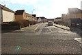
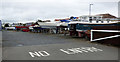
4
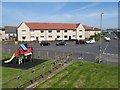
Flats and swings, Kennedy Road
A view from the ballast bank at Port Ronald. The geo-bike was doing sterling service this day!
Image: © Jonathan Wilkins
Taken: 23 May 2018
0.04 miles
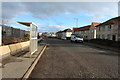
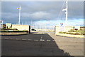
5
Troon Yacht Haven
A boatyard at the marina.
Image: © Thomas Nugent
Taken: 3 Aug 2018
0.05 miles
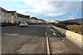
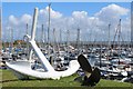
9
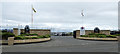
Troon Yacht Haven
The main entrance on Harbour Road.
Image: © Thomas Nugent
Taken: 3 Aug 2018
0.06 miles