IMAGES TAKEN NEAR TO
Templehill, TROON, KA10 6BH
Introduction
This page details the photographs taken nearby to Templehill, KA10 6BH by members of the Geograph project.
The Geograph project started in 2005 with the aim of publishing, organising and preserving representative images for every square kilometre of Great Britain, Ireland and the Isle of Man.

There are currently over 7.5m images from over14,400 individuals and you can help contribute to the project by visiting https://www.geograph.org.uk
Image Map
Images are licensed for reuse under creativecommons.org/licenses/by-sa/2.0
Notes
- Clicking on the map will re-center to the selected point.
- The higher the marker number, the further away the image location is from the centre of the postcode.
Image Listing (236 Images Found)
Images are licensed for reuse under creativecommons.org/licenses/by-sa/2.0
Image
Details
Distance
1
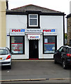
The Harbour Shop
The last stop before Belfast.
Image: © Thomas Nugent
Taken: 3 Aug 2018
0.00 miles
2
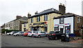
The Harbour Bar and The Harbour Shop
On Templehill.
Image: © Thomas Nugent
Taken: 3 Aug 2018
0.01 miles
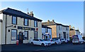
3
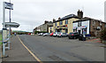
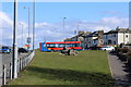
Templehill
Bus shelter, bar and shop overlooking Harbour Road.
Image: © Thomas Nugent
Taken: 3 Aug 2018
0.01 miles
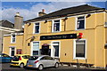
5
The Harbour Bar, Troon, South Ayrshire
Family owned bar situated on Templehill, Troon.
Appropriately, the bar is home to many interesting nautical artefacts.
Image: © Mark S
Taken: 10 Oct 2018
0.02 miles
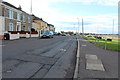
10
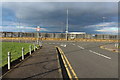
Approaching Harbour Road & Port Ranald Drive, Troon
Image: © Billy McCrorie
Taken: 29 Jan 2014
0.03 miles