IMAGES TAKEN NEAR TO
Wood Place, TROON, KA10 6BF
Introduction
This page details the photographs taken nearby to Wood Place, KA10 6BF by members of the Geograph project.
The Geograph project started in 2005 with the aim of publishing, organising and preserving representative images for every square kilometre of Great Britain, Ireland and the Isle of Man.

There are currently over 7.5m images from over14,400 individuals and you can help contribute to the project by visiting https://www.geograph.org.uk
Image Map
Images are licensed for reuse under creativecommons.org/licenses/by-sa/2.0
Notes
- Clicking on the map will re-center to the selected point.
- The higher the marker number, the further away the image location is from the centre of the postcode.
Image Listing (224 Images Found)
Images are licensed for reuse under creativecommons.org/licenses/by-sa/2.0
Image
Details
Distance
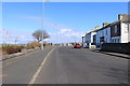

3
1 Wood Road, Troon
Dates from about 1840 http://www.britishlistedbuildings.co.uk/sc-42159-1-wood-road-former-miners-institute-inclu#.VydKmkfkoeU
Image: © Jonathan Thacker
Taken: 20 Jul 2013
0.02 miles

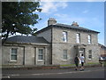
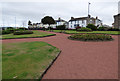
6
Garden at Harbour Road
Templehill is in the background.
Image: © Thomas Nugent
Taken: 3 Aug 2018
0.03 miles
7
Garden at Harbour Road
Templehill is in the background.
Image: © Thomas Nugent
Taken: 3 Aug 2018
0.03 miles
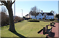
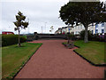
8
Community Garden, Troon
Entrance from Templehill.
Image: © Billy McCrorie
Taken: 26 Mar 2018
0.03 miles
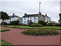
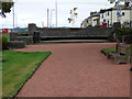
9
Garden at Harbour Road
Templehill is on the right.
Image: © Thomas Nugent
Taken: 3 Aug 2018
0.03 miles
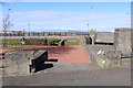
10
Garden at Harbour Road
A semi-circular concrete bench at the garden.
Image: © Thomas Nugent
Taken: 3 Aug 2018
0.03 miles