IMAGES TAKEN NEAR TO
Welbeck Crescent, TROON, KA10 6AP
Introduction
This page details the photographs taken nearby to Welbeck Crescent, KA10 6AP by members of the Geograph project.
The Geograph project started in 2005 with the aim of publishing, organising and preserving representative images for every square kilometre of Great Britain, Ireland and the Isle of Man.

There are currently over 7.5m images from over14,400 individuals and you can help contribute to the project by visiting https://www.geograph.org.uk
Image Map
Images are licensed for reuse under creativecommons.org/licenses/by-sa/2.0
Notes
- Clicking on the map will re-center to the selected point.
- The higher the marker number, the further away the image location is from the centre of the postcode.
Image Listing (202 Images Found)
Images are licensed for reuse under creativecommons.org/licenses/by-sa/2.0
Image
Details
Distance
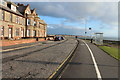
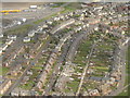
2
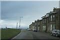
Troon sea front
These houses were perhaps once B&B's but many now seem to be either empty, being renovated or for sale.
Image: © Malcolm Neal
Taken: 8 May 2018
0.06 miles
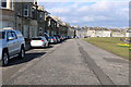
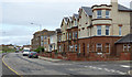
3
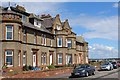
Pladda View, Titchfield Road, Troon
With fine views out to sea
Image: © Leslie Barrie
Taken: 5 Jul 2014
0.06 miles
4
Wellbeck Crescent
Off Titchfield Road.
Image: © Thomas Nugent
Taken: 3 Aug 2018
0.07 miles
5
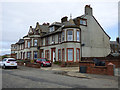
Titchfield Road
Houses overlooking the seafront at the junction with an unnamed lane.
Image: © Thomas Nugent
Taken: 3 Aug 2018
0.07 miles
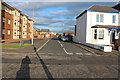
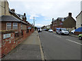
6
Welbeck Crescent, Troon
With Bradan Road, with solar panelled houses, on the left, and Titchfield Road to the right.
Image: © M J Richardson
Taken: 29 Apr 2012
0.07 miles
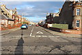
7
Titchfield Road
Wellbeck Crescent is on the right.
Image: © Thomas Nugent
Taken: 3 Aug 2018
0.07 miles