IMAGES TAKEN NEAR TO
AVOCH, IV9 8RT
Introduction
This page details the photographs taken nearby to IV9 8RT by members of the Geograph project.
The Geograph project started in 2005 with the aim of publishing, organising and preserving representative images for every square kilometre of Great Britain, Ireland and the Isle of Man.

There are currently over 7.5m images from over14,400 individuals and you can help contribute to the project by visiting https://www.geograph.org.uk
Image Map
Images are licensed for reuse under creativecommons.org/licenses/by-sa/2.0
Notes
- Clicking on the map will re-center to the selected point.
- The higher the marker number, the further away the image location is from the centre of the postcode.
Image Listing (5 Images Found)
Images are licensed for reuse under creativecommons.org/licenses/by-sa/2.0
Image
Details
Distance
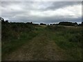
2
Heading to Avoch on the Shaltie Burn path
This is a broad path that probably deserves the status of a Core Path. The Shaltie Burn is in a deep ravine to the left of the path.
Image: © Julian Paren
Taken: 23 Jul 2024
0.12 miles
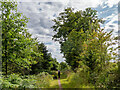
4

In Knockmuir Wood
The nearby tree houses a bird box that looks to be intended for owls.
Image: © Julian Paren
Taken: 13 Jul 2023
0.18 miles
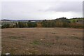
5

Forestry road across Deer Park
This track links two roads and passes Deer Park Croft House while it crosses Deer Park.
Image: © Julian Paren
Taken: 13 Jul 2023
0.20 miles