IMAGES TAKEN NEAR TO
MUNLOCHY, IV8 8PQ
Introduction
This page details the photographs taken nearby to IV8 8PQ by members of the Geograph project.
The Geograph project started in 2005 with the aim of publishing, organising and preserving representative images for every square kilometre of Great Britain, Ireland and the Isle of Man.

There are currently over 7.5m images from over14,400 individuals and you can help contribute to the project by visiting https://www.geograph.org.uk
Image Map
Images are licensed for reuse under creativecommons.org/licenses/by-sa/2.0
Notes
- Clicking on the map will re-center to the selected point.
- The higher the marker number, the further away the image location is from the centre of the postcode.
Image Listing (3 Images Found)
Images are licensed for reuse under creativecommons.org/licenses/by-sa/2.0
Image
Details
Distance
1
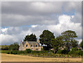
Wester Auchterflow
This fine farmhouse was on the market being empty at the time of our visit. It was being sold with a recently planted wood at the front of the property.
Image: © Julian Paren
Taken: 8 Sep 2007
0.08 miles
2
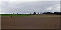
Auchterflow fields
A typical Black Isle agricultural scene.
Image: © Nick Ray
Taken: 21 Apr 2007
0.18 miles