IMAGES TAKEN NEAR TO
Poyntzfield, DINGWALL, IV7 8LX
Introduction
This page details the photographs taken nearby to IV7 8LX by members of the Geograph project.
The Geograph project started in 2005 with the aim of publishing, organising and preserving representative images for every square kilometre of Great Britain, Ireland and the Isle of Man.

There are currently over 7.5m images from over14,400 individuals and you can help contribute to the project by visiting https://www.geograph.org.uk
Image Map
Images are licensed for reuse under creativecommons.org/licenses/by-sa/2.0
Notes
- Clicking on the map will re-center to the selected point.
- The higher the marker number, the further away the image location is from the centre of the postcode.
Image Listing (20 Images Found)
Images are licensed for reuse under creativecommons.org/licenses/by-sa/2.0
Image
Details
Distance
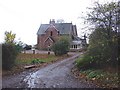
1
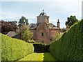
Poyntzfield House
A glimpse of the rear of the 18th Century house from the interesting herb and medicinal plants nursery.
Image: © Greg Fitchett
Taken: 22 Jul 2014
0.08 miles
2
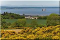
Poyntzfield Mains
View from the edge of the track at Mount High towards Poyntzfield Mains and over the Cromarty Firth
Image: © valenta
Taken: 29 May 2020
0.09 miles
3
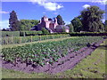
Poyntzfield house from the herb nursery gardens
The nursery gardens are enclosed within an old walled garden area which once belonged to the house and are an oasis of calm.
Image: © Alastair Morton
Taken: 8 Jun 2008
0.11 miles
4
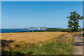
Field at Poyntzfield Mains
A field of barley waiting harvesting at Poyntzfield Mains overlooking the Cromarty Firth
Image: © valenta
Taken: 6 Aug 2020
0.11 miles
5
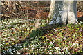
Snowdrops at Poyntzfield
Poyntzfield was part of Scotland's Snowdrop Festival in 2016, but was not listed for this event in 2017. There are no access problems, as you can park in the Herb Garden carpark (although the Herb Garden is closed in the winter).
Image: © Julian Paren
Taken: 13 Feb 2017
0.13 miles
6
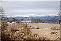
View over the Black Isle fields
The buildings of Poyntzfield Farm and in the far distance, the snow covered mountains of the Highlands, at least 20 km away.
Image: © Bill Harrison
Taken: 3 Apr 2013
0.14 miles
7
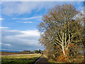
Farm track to Poyntzfield
This track is part of the network promoted by Transition Black Isle for active travel between centres of population on the Black Isle. This track is a suggested cycle route "on an unsurfaced path or track".
Image: © Julian Paren
Taken: 1 Mar 2016
0.15 miles
8
Poyntzfield Mains
Poyntzfield Mains is accessed from the B9163 shore road to Cromarty.
Image: © Alasdair Macdonald
Taken: 21 Nov 2007
0.17 miles
9
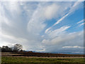
Weather clearance, Poyntzfield, Black Isle
On the far horizon is the snow-covered Ben Wyvis.
Image: © Julian Paren
Taken: 1 Mar 2016
0.17 miles
10
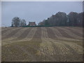
Poyntzfield Mains
Poyntzfield Mains overlooks Udale Bay, across this stubble field.
Image: © Alasdair Macdonald
Taken: 21 Nov 2007
0.18 miles