IMAGES TAKEN NEAR TO
Balblair, DINGWALL, IV7 8LN
Introduction
This page details the photographs taken nearby to IV7 8LN by members of the Geograph project.
The Geograph project started in 2005 with the aim of publishing, organising and preserving representative images for every square kilometre of Great Britain, Ireland and the Isle of Man.

There are currently over 7.5m images from over14,400 individuals and you can help contribute to the project by visiting https://www.geograph.org.uk
Image Map
Images are licensed for reuse under creativecommons.org/licenses/by-sa/2.0
Notes
- Clicking on the map will re-center to the selected point.
- The higher the marker number, the further away the image location is from the centre of the postcode.
Image Listing (9 Images Found)
Images are licensed for reuse under creativecommons.org/licenses/by-sa/2.0
Image
Details
Distance
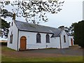
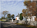
1
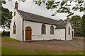
Resolis Free Church Of Scotland
Dating from 1865 the Resolis Free Church is category C listed.
https://britishlistedbuildings.co.uk/200348428-resolis-free-church-resolis#.XzkmODXTVaQ
Image: © valenta
Taken: 12 Jul 2020
0.03 miles
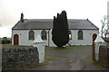
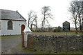
5
Resolis Free Church
Strikingly immaculate in a fine setting beside an equally impressive Manse.
Image: © Julian Paren
Taken: 20 Oct 2016
0.04 miles
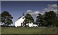
7

Minor road dropping towards Resolis Free Church manse
Image: © Alan Reid
Taken: 22 Feb 2024
0.17 miles
8
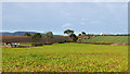
Farming on the Black Isle - October
Plenty of variety in the crops sown here.
Image: © Julian Paren
Taken: 20 Oct 2016
0.18 miles
9
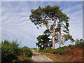
Road from Newmills to Resolis School
A straight road with some old Scots Pines.
Image: © Julian Paren
Taken: 20 Oct 2016
0.25 miles