IMAGES TAKEN NEAR TO
Culbokie, DINGWALL, IV7 8JP
Introduction
This page details the photographs taken nearby to IV7 8JP by members of the Geograph project.
The Geograph project started in 2005 with the aim of publishing, organising and preserving representative images for every square kilometre of Great Britain, Ireland and the Isle of Man.

There are currently over 7.5m images from over14,400 individuals and you can help contribute to the project by visiting https://www.geograph.org.uk
Image Map
Images are licensed for reuse under creativecommons.org/licenses/by-sa/2.0
Notes
- Clicking on the map will re-center to the selected point.
- The higher the marker number, the further away the image location is from the centre of the postcode.
Image Listing (40 Images Found)
Images are licensed for reuse under creativecommons.org/licenses/by-sa/2.0
Image
Details
Distance
1
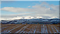
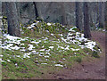
Stubble field near Culbokie
The west side of the Black Isle provides views towards Ben Wyvis. Often white when the Black Isle is black.........
Image: © Julian Paren
Taken: 16 Dec 2017
0.10 miles
2
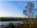
Outlook towards Beinn Wyvis, Culbokie Wood
The pond by the edge of the wood is often much smaller than this. It is marked as permanent water on OS maps. Houses in Culbokie village are visible.
Image: © Julian Paren
Taken: 13 Feb 2020
0.10 miles
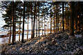
3
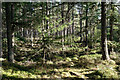
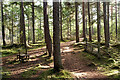
Segment of Culbokie Wood
A fairly open Scots Pine plantation.
Image: © Julian Paren
Taken: 26 Sep 2022
0.13 miles
4
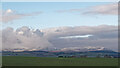
Outlook to Ben Wyvis from Culbokie Wood
An early January comparison with a visit recorded for Geograph in December 2021. Image The new view is more of a telephoto image.
Image: © Julian Paren
Taken: 3 Jan 2022
0.13 miles
5
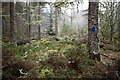
Old fence line in Culbokie Wood (Glascairn Wood)
The stile and gate are redundant as the fence is incomplete here. There are excellent well-used tracks here that are not captured by OS mapping.
Image: © Julian Paren
Taken: 26 Sep 2022
0.13 miles
6
Alongside the track through the woods behind Culbokie
Culbokie dog walkers have a fine set of paths and tracks through the woods behind their village. An old wall, now falling down, lies beside one section of the path.
Image: © Julian Paren
Taken: 26 Mar 2013
0.13 miles
7
Christmas trail in Culbokie Wood
The local shop sells a map with locations of surprise points dotted through Culbokie Wood and the footpaths that connect them. We met folk who could not "read" the map and who had failed to spot the "attractions" while my wife and I found there were far more than mapped. All good Christmas fun with one well dressed Christmas tree at a dark location. In this picture the door on the tree could open with a latch to reveal a painting of angels.
Image: © Julian Paren
Taken: 22 Dec 2021
0.14 miles
8
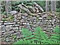
Old wall in the woods at Culbokie
The wall is a feature of a popular walk with dogs, lying parallel to a fine track,unmarked on OS mapping (but clearly indicated on OpenStreet Map). The wall is complete in places but mainly dilapidated. It also features in Image
Image: © Julian Paren
Taken: 19 Jul 2014
0.14 miles
9
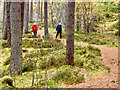
Walking a dog in Culbokie Wood
A popular path for walkers and their dogs for inhabitants of Culbokie and further afield.
Image: © Julian Paren
Taken: 19 Oct 2017
0.14 miles
10
Side of the Glascairn Ridge, Culbokie Wood
The Glascairn Ridge is an esker.
Image: © Julian Paren
Taken: 12 Feb 2021
0.14 miles