IMAGES TAKEN NEAR TO
Birch Drive, DINGWALL, IV7 8ES
Introduction
This page details the photographs taken nearby to Birch Drive, IV7 8ES by members of the Geograph project.
The Geograph project started in 2005 with the aim of publishing, organising and preserving representative images for every square kilometre of Great Britain, Ireland and the Isle of Man.

There are currently over 7.5m images from over14,400 individuals and you can help contribute to the project by visiting https://www.geograph.org.uk
Image Map
Images are licensed for reuse under creativecommons.org/licenses/by-sa/2.0
Notes
- Clicking on the map will re-center to the selected point.
- The higher the marker number, the further away the image location is from the centre of the postcode.
Image Listing (19 Images Found)
Images are licensed for reuse under creativecommons.org/licenses/by-sa/2.0
Image
Details
Distance
2
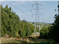
Line of pylons by Maryburgh
The line heads between segments of the forest towards two wind turbines on the hillside beyond.
Image: © Julian Paren
Taken: 23 Sep 2017
0.10 miles
3
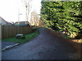
Old road to Loch Ussie
The old road from Maryburgh to Loch Ussie is now much overgrown, but still serves as a footpath.
Image: © Alpin Stewart
Taken: 3 Nov 2013
0.11 miles
5
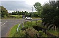
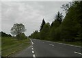
Junction on the A835 at Maryburgh
The culvert carries the Ussie Burn.
Image: © Alan Reid
Taken: 4 Sep 2017
0.17 miles
6
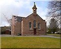
Maryburgh Free Church
This church dates from the 1840s, and is part of the 'Maryburgh and Killearnan' congregation of the Free Church of Scotland.
Image: © Craig Wallace
Taken: 18 Mar 2014
0.18 miles
7

Cows
I went to take a photograph of the view and thought it would be nice to have some cows in the foreground. I ended up taking photographs of cows!
Image: © Dorcas Sinclair
Taken: 21 May 2005
0.19 miles
8

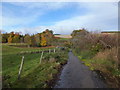
Looking toward the Cromarty Firth
After doing a geocache in the area we found some very inquisitive cows.
Image: © Dorcas Sinclair
Taken: 21 May 2005
0.19 miles
9
Former Tollhouse by the A862, Maryburgh
Maryburgh by the A862, in parish of Maryburgh (Highland District), Toll House, Wrightfield Park, Maryburgh, IV7 8ER.
Surveyed
Milestone Society National ID: HI.MAR
Image: © Milestone Society
Taken: Unknown
0.19 miles