IMAGES TAKEN NEAR TO
Conon Bridge, DINGWALL, IV7 8DN
Introduction
This page details the photographs taken nearby to IV7 8DN by members of the Geograph project.
The Geograph project started in 2005 with the aim of publishing, organising and preserving representative images for every square kilometre of Great Britain, Ireland and the Isle of Man.

There are currently over 7.5m images from over14,400 individuals and you can help contribute to the project by visiting https://www.geograph.org.uk
Image Map
Images are licensed for reuse under creativecommons.org/licenses/by-sa/2.0
Notes
- Clicking on the map will re-center to the selected point.
- The higher the marker number, the further away the image location is from the centre of the postcode.
Image Listing (8 Images Found)
Images are licensed for reuse under creativecommons.org/licenses/by-sa/2.0
Image
Details
Distance
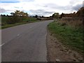
1
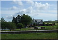
House near Conon Bridge
On National Cycle Route 1.
Image: © JThomas
Taken: 21 Jul 2014
0.03 miles
2
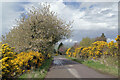
Colour at Conon Brae
Spring blossom at the sides of a minor road east of Conon Bridge.
Image: © Richard Dorrell
Taken: 10 May 2021
0.04 miles
3
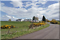
Housing at Conon Brae
A sign at the entrance reads 'Corntown Dairy', though it is not clear if this is the name of the road or of a building.
Image: © Richard Dorrell
Taken: 10 May 2021
0.04 miles
4
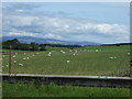
Grazing near Conon Bridge
Off National Cycle Route 1.
Image: © JThomas
Taken: 21 Jul 2014
0.05 miles
5
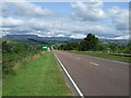
A835 heading north west
Towards Conon Bridge.
Image: © JThomas
Taken: 21 Jul 2014
0.08 miles
6
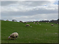
Sheep and young lambs below Torgorm
A sign that spring has come to the Black Isle.
Image: © Julian Paren
Taken: 19 Apr 2016
0.12 miles
7
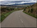
Unclassified road near Conon Bridge
This was once the A835.
Image: © Steven Brown
Taken: 26 Oct 2013
0.20 miles
8
Unclassified road near Conon Bridge
This was once the A835.
Image: © Steven Brown
Taken: 26 Oct 2013
0.22 miles