IMAGES TAKEN NEAR TO
MUIR OF ORD, IV6 7TW
Introduction
This page details the photographs taken nearby to IV6 7TW by members of the Geograph project.
The Geograph project started in 2005 with the aim of publishing, organising and preserving representative images for every square kilometre of Great Britain, Ireland and the Isle of Man.

There are currently over 7.5m images from over14,400 individuals and you can help contribute to the project by visiting https://www.geograph.org.uk
Image Map (Loading...)


Getting Data...Please wait
Leaflet Map data © OpenStreetMap
Images are licensed for reuse under creativecommons.org/licenses/by-sa/2.0
Notes
- Clicking on the map will re-center to the selected point.
- The higher the marker number, the further away the image location is from the centre of the postcode.
Image Listing (11 Images Found)
Images are licensed for reuse under creativecommons.org/licenses/by-sa/2.0
Image
Details
Distance
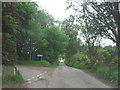
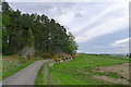
2
Corrie Road runs beside Birch Wood
Birch Wood seems to have gained a few hemlock conifers but birches still abound!
Image: © Stuart Logan
Taken: 4 Jun 2011
0.09 miles
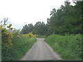
3
Lane to Upper Ardnagrask
In Gaelic Ardnagrask translates to 'Height of the Crossings'. In his book 'Place-names of Ross & Cromarty' p109 Watson tells us that the crossings referred to a system of land allocation called cross-rigs. This was to ensure that each crofter got some good and some not-so-good land to work.
Image: © Stuart Logan
Taken: 4 Jun 2011
0.13 miles
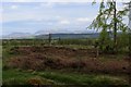
4
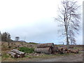
Cleared forest, by Upper Ardnagrask
This area is marked on the map as a forest, named "Birch Wood". It looks like it has been cleared fairly recently, leaving a few dead trees still standing.
There is now a good view towards the outskirts of Muir of Ord. The large white building to the left is part of the Glen Ord Distillery, with the Cromarty Firth just visible beyond it.
Image: © Craig Wallace
Taken: 22 Sep 2012
0.13 miles
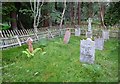
5
Upper Ardnagrask Cemetery
The gravestones mainly commemorate the families of Colonel Alexander Mackenzie and Lieutenant-Colonel Angus Douglas-Hamilton, both officers of Highland regiments. Douglas-Hamilton received the Victoria Cross.
Image: © Tim Heaton
Taken: 11 May 2018
0.14 miles
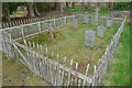
6
Burial ground, by Upper Ardnagrask
A small burial ground, hidden amongst the trees. It is surrounded by a wooden fence, which is falling down in places.
It appears the gravestones are mostly for the family of Lt Col A. Douglas-Hamilton and Colonel Alexander F. Mackenzie. There is also a gravestone outside of the fence for Jock, a "faithful friend", presumably a dog.
For details, see the Highland Council Historic Environment Record: http://her.highland.gov.uk/SingleResult.aspx?uid=MHG31480
Image: © Craig Wallace
Taken: 20 Aug 2012
0.15 miles
7
In Birch Wood
Much of this woodland has been felled, although a tiny graveyard is still concealed by trees just a few paces from where I was standing.
Image: © Chris Heaton
Taken: 11 May 2018
0.16 miles
9
The road to Muir of Ord passing Birch Wood
The wood holds a small cemetery Image
Image: © Tim Heaton
Taken: 11 May 2018
0.16 miles
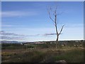
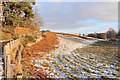
10
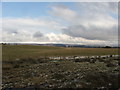
Farmland
Much of this grid is farmland on the outskirts of Muir of Ord, Ben Wyvis, in the background, is shrouded by cloud on this cold spring day.
Image: © David Maclennan
Taken: 16 Mar 2006
0.21 miles