IMAGES TAKEN NEAR TO
Chapelton Place, MUIR OF ORD, IV6 7TG
Introduction
This page details the photographs taken nearby to Chapelton Place, IV6 7TG by members of the Geograph project.
The Geograph project started in 2005 with the aim of publishing, organising and preserving representative images for every square kilometre of Great Britain, Ireland and the Isle of Man.

There are currently over 7.5m images from over14,400 individuals and you can help contribute to the project by visiting https://www.geograph.org.uk
Image Map
Images are licensed for reuse under creativecommons.org/licenses/by-sa/2.0
Notes
- Clicking on the map will re-center to the selected point.
- The higher the marker number, the further away the image location is from the centre of the postcode.
Image Listing (18 Images Found)
Images are licensed for reuse under creativecommons.org/licenses/by-sa/2.0
Image
Details
Distance
1
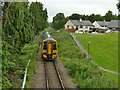
Railway northwards from Muir of Ord
The line is single track from here to Dingwall. This train is headed to Kyle of Lochalsh (where it used to connect with a ferry).
Image: © Stephen Craven
Taken: 5 Jul 2019
0.05 miles
2
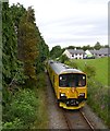
Network Rail test train, approaching Muir of Ord
This train is the Network Rail Track Recording Unit. It contains a variety of equipment for measuring the condition of track.
It is a diesel multiple unit, designated as Class 950 - the only train of this class - with number 950001. It is based on the Class 150 Sprinter.
Here it was returning from Kyle of Lochalsh, heading towards the depot at Inverness. It passed a ScotRail train waiting at Muir of Ord station.
Image: © Craig Wallace
Taken: 14 Jul 2014
0.06 miles
3
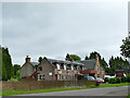
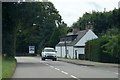
The Ord Arms (2)
A coaching inn of 1904 on what was the main road to the far north (later the A9, now the A862). It was later extended but is still in equivalent use as a hotel and local pub. See also Image
Image: © Stephen Craven
Taken: 5 Jul 2019
0.06 miles
4
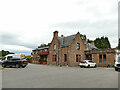
The Ord Arms
A coaching inn of 1904 on what was the main road to the far north (later the A9, now the A862). It was later extended but is still in equivalent use as a hotel and local pub. We stayed here for a few nights while exploring the area and were made very welcome. See also Image
Image: © Stephen Craven
Taken: 5 Jul 2019
0.06 miles
5
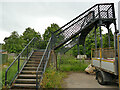
Railway footbridge off Highfield Circle
The bridge is obviously older than the modern housing nearby. It originally just led from the main road beyond to a path on this side of the tracks heading into farmland north-east of the town.
Image: © Stephen Craven
Taken: 4 Jul 2019
0.07 miles
6
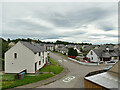
Highfield Circle
Viewed from the railway footbridge Image
Image: © Stephen Craven
Taken: 5 Jul 2019
0.08 miles
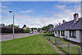
7
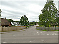
Chestnut Grove
A street of bungalows.
Image: © Stephen Craven
Taken: 5 Jul 2019
0.08 miles
9
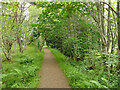
Footpath through Ord Wood
Little of the original woodland is left, only this short section with a footpath connecting the main road to a housing estate.
Image: © Stephen Craven
Taken: 5 Jul 2019
0.13 miles
10
Seaforth Road, Muir of Ord
Looking north from the car park of the Parish Church (see Image). Behind the photographer, this largely residential road leads into the centre of the small town of Muir of Ord.
Image: © Richard Dorrell
Taken: 17 Jun 2014
0.19 miles