IMAGES TAKEN NEAR TO
MUIR OF ORD, IV6 7RB
Introduction
This page details the photographs taken nearby to IV6 7RB by members of the Geograph project.
The Geograph project started in 2005 with the aim of publishing, organising and preserving representative images for every square kilometre of Great Britain, Ireland and the Isle of Man.

There are currently over 7.5m images from over14,400 individuals and you can help contribute to the project by visiting https://www.geograph.org.uk
Image Map (Loading...)


Getting Data...Please wait
Leaflet Map data © OpenStreetMap
Images are licensed for reuse under creativecommons.org/licenses/by-sa/2.0
Notes
- Clicking on the map will re-center to the selected point.
- The higher the marker number, the further away the image location is from the centre of the postcode.
Image Listing (4 Images Found)
Images are licensed for reuse under creativecommons.org/licenses/by-sa/2.0
Image
Details
Distance
1
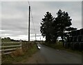
Unclassified road at Allangrange Park
Image: © Douglas Nelson
Taken: 10 Nov 2020
0.16 miles
2
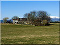
Croft in Newton of Kinkell
With so many trees surrounding the croft, one must imagine it can be a windy spot! Ben Wyvis with snow at higher levels dominates the background.
Image: © Julian Paren
Taken: 12 Mar 2014
0.16 miles
3
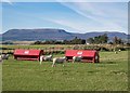
Newton of Kinkell
Sheep in a field viewed from the minor road from Newmore to the A835. The vast plateau of Ben Wyvis dominates any view to the north from The Black Isle
Image: © valenta
Taken: 19 Sep 2019
0.19 miles
4
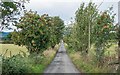
Rowan tree line road Muir of allangrange
The single track road from the A835 at Newton Piggery to the B9169 at Muir of Allangrange. Rowan trees full with berries line the road
Image: © valenta
Taken: 17 Aug 2018
0.20 miles