IMAGES TAKEN NEAR TO
Achonachie Road, MUIR OF ORD, IV6 7QE
Introduction
This page details the photographs taken nearby to Achonachie Road, IV6 7QE by members of the Geograph project.
The Geograph project started in 2005 with the aim of publishing, organising and preserving representative images for every square kilometre of Great Britain, Ireland and the Isle of Man.

There are currently over 7.5m images from over14,400 individuals and you can help contribute to the project by visiting https://www.geograph.org.uk
Image Map
Images are licensed for reuse under creativecommons.org/licenses/by-sa/2.0
Notes
- Clicking on the map will re-center to the selected point.
- The higher the marker number, the further away the image location is from the centre of the postcode.
Image Listing (27 Images Found)
Images are licensed for reuse under creativecommons.org/licenses/by-sa/2.0
Image
Details
Distance
1
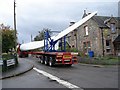
Wind turbine blade at Marybank
The three giant blades of each turbine were slowly driven to the new wind farm site near Marybank along roads certainly not designed for such long lorries.
Image: © Anne Petty
Taken: 28 Sep 2009
0.03 miles
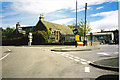
2
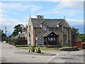
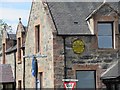
Former post office, Marybank
Still marked up as such on 1:25,000 mapping but has been closed for a long time. The junction is a crossroads with the main road sweeping right and left and straight on being minor roads.
Image: © Richard Webb
Taken: 27 Jul 2018
0.03 miles
3
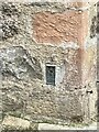
Flush Bracket OSBM G1718 - Marybank, former Post Office
https://www.bench-marks.org.uk/bm404
Image: © thejackrustles
Taken: 29 Apr 2022
0.03 miles
4
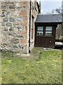
Location of Flush Bracket OSBM G1718 - Marybank, former Post Office
Image: © thejackrustles
Taken: 29 Apr 2022
0.03 miles
5
AA sign, Marybank
On the former post office at the crossroads. Contin 2 1/2, Muir of Ord 4. No units but obviously miles.
Image: © Richard Webb
Taken: 27 Jul 2018
0.04 miles
6
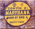
Old circular AA and Royal Scottish Automobile Club sign on the A832 at Marybank
Old AA and Royal Scottish Automobile Club sign set on the east facing wall of a house on the northwest side of the crossroads on the A832 at Marybank, 4 miles northwest of Muir of Ord.
This is the Scotland, circular, AA and Royal Scottish Automobile Club badges at top type showing distances Contin 2½ Muir of Ord 4.
There were five series of AA signs, mostly dating from 1923 and made by Francis & Co / Franco in Deptford, London. The village name and distance to London were displayed.
See also https://www.geograph.org.uk/photo/5982787 , https://www.flickr.com/photos/24718842@N04/2457561343 and https://www.flickr.com/photos/keith-v/52563247883.
Milestone Society National ID: HI-MARYB
Image: © Milestone Society
Taken: Unknown
0.04 miles
7
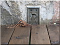
Ordnance Survey Flush Bracket G1718
This partly buried bracket can be found on the wall of a private dwelling - former Post office - in Marybank. The benchmark height is recorded as being 26.619 metres above sea level.
For more detail see : http://www.bench-marks.org.uk/bm404
Image: © Peter Wood
Taken: 5 Jun 2017
0.04 miles
8
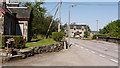
Marybank
The A832 heading westwards through the small village of Marybank.
Image: © Trevor Littlewood
Taken: 27 May 2012
0.04 miles
9
Marybank
The main junction in the village, with the primary school in the background.
Image: © Carol Walker
Taken: Unknown
0.04 miles
10
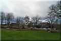
Playpark, Marybank
This large, well equipped playpark stands in the corner of a recreation field, opposite the Fairburn Memorial Hall - visible through the trees.
Image: © Richard Dorrell
Taken: 8 Dec 2020
0.04 miles