IMAGES TAKEN NEAR TO
Drumnadrochit, INVERNESS, IV63 6XE
Introduction
This page details the photographs taken nearby to IV63 6XE by members of the Geograph project.
The Geograph project started in 2005 with the aim of publishing, organising and preserving representative images for every square kilometre of Great Britain, Ireland and the Isle of Man.

There are currently over 7.5m images from over14,400 individuals and you can help contribute to the project by visiting https://www.geograph.org.uk
Image Map
Images are licensed for reuse under creativecommons.org/licenses/by-sa/2.0
Notes
- Clicking on the map will re-center to the selected point.
- The higher the marker number, the further away the image location is from the centre of the postcode.
Image Listing (8 Images Found)
Images are licensed for reuse under creativecommons.org/licenses/by-sa/2.0
Image
Details
Distance
2
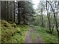
Path under Creag Mony
Now used by the Affric Kintail Way.
Image: © Richard Webb
Taken: 25 Jul 2016
0.16 miles
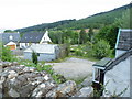
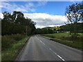
4
Flood plain at Easter Milton, Drumnadrochit
A new house is well sited to avoid flood problems.
Image: © Alan Reid
Taken: 5 Dec 2014
0.19 miles
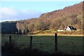
5
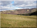
Looking north from grassland near Craig Monie
Image: © Sarah McGuire
Taken: 27 Mar 2010
0.20 miles
6
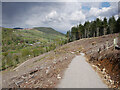
Path, by Craig Mony
A quite smooth gravel path, part of the waymarked trails around the woods.
Looks like this area was felled quite recently, and has now been replanted, with trees in tubes.
Image: © Craig Wallace
Taken: 16 May 2021
0.21 miles
8
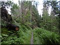
Path through a pine forest
Singletrack on the Affric Kintail Way. After a climb just past here, the route to Cannich is nearly all on roads.
Image: © Richard Webb
Taken: 25 Jul 2016
0.24 miles