IMAGES TAKEN NEAR TO
Kirkhill, INVERNESS, IV5 7PX
Introduction
This page details the photographs taken nearby to IV5 7PX by members of the Geograph project.
The Geograph project started in 2005 with the aim of publishing, organising and preserving representative images for every square kilometre of Great Britain, Ireland and the Isle of Man.

There are currently over 7.5m images from over14,400 individuals and you can help contribute to the project by visiting https://www.geograph.org.uk
Image Map
Images are licensed for reuse under creativecommons.org/licenses/by-sa/2.0
Notes
- Clicking on the map will re-center to the selected point.
- The higher the marker number, the further away the image location is from the centre of the postcode.
Image Listing (17 Images Found)
Images are licensed for reuse under creativecommons.org/licenses/by-sa/2.0
Image
Details
Distance
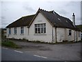
2
Former Inchmore Primary School
This was Inchmore Primary School. It closed in about 1996, pupils now travel to Kirkhill Primary School.
I think the building to the left of the playing fields was the school canteen. This has since been used by a variety of community groups, including staging a pantomime for a number of years.
Image: © Craig Wallace
Taken: 30 Nov 2011
0.06 miles
3
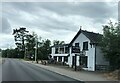
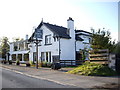
Old North Inn at Inchmore
Beside the A862
Image: © Eirian Evans
Taken: 29 Jun 2022
0.14 miles
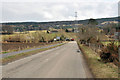
4
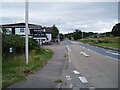
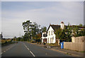
The A862 by the Old North Inn at Inchmore
Image: © Douglas Nelson
Taken: 10 Aug 2021
0.15 miles
5
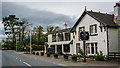
Old North Inn, Inchmore
Formerly the Bog Roy Inn; Inchmore was once called Bog Roy.
Image: © Stanley Howe
Taken: 7 Oct 2009
0.15 miles
6
The Old North Inn
On the A862, Inchmore.
Image: © Peter Bond
Taken: 14 Oct 2015
0.16 miles
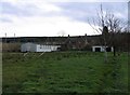
10
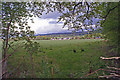
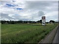
Over the fields
Looking south east from the bank of the Newton Burn towards buildings at the side of the A862.
Image: © Richard Dorrell
Taken: 5 May 2019
0.20 miles