IMAGES TAKEN NEAR TO
Kirkhill, INVERNESS, IV5 7PH
Introduction
This page details the photographs taken nearby to IV5 7PH by members of the Geograph project.
The Geograph project started in 2005 with the aim of publishing, organising and preserving representative images for every square kilometre of Great Britain, Ireland and the Isle of Man.

There are currently over 7.5m images from over14,400 individuals and you can help contribute to the project by visiting https://www.geograph.org.uk
Image Map
Images are licensed for reuse under creativecommons.org/licenses/by-sa/2.0
Notes
- Clicking on the map will re-center to the selected point.
- The higher the marker number, the further away the image location is from the centre of the postcode.
Image Listing (8 Images Found)
Images are licensed for reuse under creativecommons.org/licenses/by-sa/2.0
Image
Details
Distance
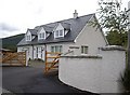
1
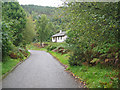
House at Cabrich
One of the houses on a short dead-end road below the wooded Tor Clunes.
Image: © John Allan
Taken: 16 Sep 2008
0.08 miles
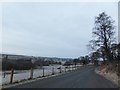
2
Minor road and housing at Cabrich
Looking north-eastward.
Image: © Peter Wood
Taken: 1 Jun 2021
0.09 miles
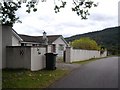
3
Lythmore
A new build numbered '5 Cabrich'.
Image: © Stanley Howe
Taken: 9 Oct 2009
0.09 miles
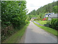
4
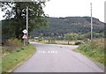
Road junction between Cabrich and Milifiach
Tor Clunes Image in background.
Image: © Stanley Howe
Taken: 9 Oct 2009
0.13 miles
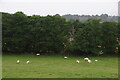
6
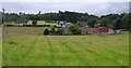
Boots n Paddles, Cabrich
A mixture of fields and houses in Cabrich.
The nearer buildings with the red roofs is the base of Boots n Paddles. They offer a variety of outdoor activities, including walking, mountain biking, kayaking and canoeing. So they often store canoes and kayaks here. See http://www.boots-n-paddles.co.uk/
Image: © Craig Wallace
Taken: 30 Jul 2012
0.16 miles