IMAGES TAKEN NEAR TO
Glendale, ISLE OF SKYE, IV55 8WL
Introduction
This page details the photographs taken nearby to IV55 8WL by members of the Geograph project.
The Geograph project started in 2005 with the aim of publishing, organising and preserving representative images for every square kilometre of Great Britain, Ireland and the Isle of Man.

There are currently over 7.5m images from over14,400 individuals and you can help contribute to the project by visiting https://www.geograph.org.uk
Image Map (Loading...)


Getting Data...Please wait
Leaflet Map data © OpenStreetMap
Images are licensed for reuse under creativecommons.org/licenses/by-sa/2.0
Notes
- Clicking on the map will re-center to the selected point.
- The higher the marker number, the further away the image location is from the centre of the postcode.
Image Listing (16 Images Found)
Images are licensed for reuse under creativecommons.org/licenses/by-sa/2.0
Image
Details
Distance
1
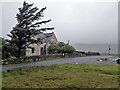
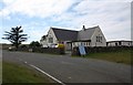
Former school and school house
The former Borrodale Primary School closed in 2007. The building currently stands empty, and is becoming increasingly derelict.
More information: Image
Image: © Richard Dorrell
Taken: 5 Jul 2019
0.00 miles
2
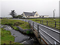
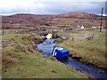
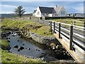
Bridge and former school
The photograph is taken from the road bridge over the Abhainn Poll-Iosgainn.
The building is the former Borrodale Primary School. The school closed in 2007 due to a decline in local pupil numbers.
Attempts have been made to make use the school building, most notably with the establishment of an exhibition on heritage and a community café, run by volunteers. However these attempts were ultimately unsuccessful and the school has become disused again.
The Glendale Trust have now taken ownership of the school and are looking to redevelop the site to take it into community use.
Image: © Richard Dorrell
Taken: 5 Jul 2019
0.01 miles
3
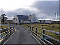
Borrodale primary school
Seen from the bridge over Abhainn Poll-Iosgainn. The road is the B884 to Milovaig.
The school is currently not in use as there are no pupils on the school roll.
Image: © Richard Dorrell
Taken: 21 Jan 2009
0.01 miles
4
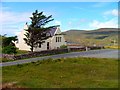
Bun-Sgoil Bhorradail
Borrodale Primary School.
Image: © Dave Fergusson
Taken: 23 Jul 2007
0.02 miles
5
Borrodale Primary School
Currently not being used as a school due to lack of children.
Instead it is holding a heritage exhibition including details of the martyrs who struggled to improve the rights of the local crofters.
It also acts as a most welcome cafe with some excellent carrot cake!
Image: © Bob Embleton
Taken: 13 Aug 2010
0.03 miles
6
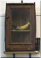
The Martyrs' Horn
Inside Borrodale Primary School - currently used as a cafe.
This was John MacPherson's horn dating from 1883.
It was used to warn the crofters when the authorities arrived during their struggle for land reform.
Not only were fifty fully armed policemen used to arrest the ringleaders, but four Naval gunboats were sent to the Colbost jetty.
They unloaded three regiments of marines, two of infantry and one of artillery.
Image: © Bob Embleton
Taken: 13 Aug 2010
0.03 miles
7
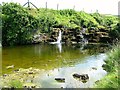
Waterfall on Unnamed Burn
Opposite Bun-Sgoil Bhorradail (Borrodale Primary School).
Image: © Dave Fergusson
Taken: 23 Jul 2007
0.04 miles
8
Water recycling?
A recent storm has relocated the recycling bins which are usually in the car park opposite Borrodale primary school. (Just to the left of this picture).
They are now in the Abhainn Poll-Iosgainn.
Image: © Richard Dorrell
Taken: 21 Jan 2009
0.04 miles
9
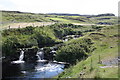
Waterfall near Borrodale Primary School
Just over the road from the school - an idyllic spot.
Image: © Bob Embleton
Taken: 13 Aug 2010
0.04 miles
10
Bun-Sgoil Bhorradail
Borrodale Primary School. What a brilliant environment for a primary education.
Image: © John Allan
Taken: 19 Feb 2006
0.08 miles