IMAGES TAKEN NEAR TO
Lochcarron, STRATHCARRON, IV54 8YD
Introduction
This page details the photographs taken nearby to IV54 8YD by members of the Geograph project.
The Geograph project started in 2005 with the aim of publishing, organising and preserving representative images for every square kilometre of Great Britain, Ireland and the Isle of Man.

There are currently over 7.5m images from over14,400 individuals and you can help contribute to the project by visiting https://www.geograph.org.uk
Image Map (Loading...)


Getting Data...Please wait
Leaflet Map data © OpenStreetMap
Images are licensed for reuse under creativecommons.org/licenses/by-sa/2.0
Notes
- Clicking on the map will re-center to the selected point.
- The higher the marker number, the further away the image location is from the centre of the postcode.
Image Listing (47 Images Found)
Images are licensed for reuse under creativecommons.org/licenses/by-sa/2.0
Image
Details
Distance
1
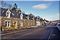
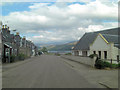
Main Street, Lochcarron
Looking east from outside the Parish Church. The road is part of the A896. Not a lot has changed in this view since Anne Burgess took her photo in 1971 - see Image
Image: © Richard Dorrell
Taken: 16 Feb 2014
0.01 miles
2
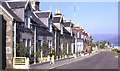
Lochcarron
This is the main street of the village of Lochcarron, almost on the shore of the loch. It hasn't changed a lot in the last 45 years; see Image
Image: © Anne Burgess
Taken: Unknown
0.01 miles
3
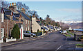
Main Street, Lochcarron
Looking east. The road is part of the A896.
Image: © Richard Dorrell
Taken: 16 Feb 2014
0.02 miles
4
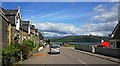
Main Street, Lochcarron
A similar view to Image, but 35 years later. On the right, you can just see an edge of the Church of Scotland building; the nearest two houses are Ashgrove and Caber Feidh (I bought the former in 2006).
Image: © Toby Speight
Taken: 26 Jun 2006
0.02 miles
5
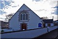
Parish church, entrance
Entrance door and gable end of the Lochcarron Parish Church. See also: Image
Image: © Richard Dorrell
Taken: 16 Feb 2014
0.02 miles
6
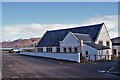
A896 goes through Lochcarron
The building on the right is the Church of Scotland.
Image: © Stuart Logan
Taken: 3 Jun 2011
0.02 miles
7
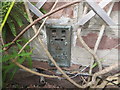
Ordnance Survey Flush Bracket G1927
This bracket can be found on the wall of a private dwelling in Lochcarron. The benchmark's recorded height is 5.939 metres above sea level.
For more detail see : https://www.bench-marks.org.uk/bm11777
Image: © Peter Wood
Taken: 4 Sep 2019
0.03 miles
8
Parish Church, Lochcarron
Also known as West Church, and now a Church of Scotland. The church was formerly the United Free Church, and was designed by William Mackenzie in 1910. Entrance: Image
Image: © Richard Dorrell
Taken: 16 Feb 2014
0.03 miles
9
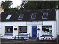
Waterside Cafe, Lochcarron
A popular spot for a snack.
Image: © Willie Mair
Taken: 9 Jul 2008
0.03 miles
10
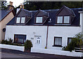
Carron cottage
A kenspeckle cottage on Lochcarron Main Street
Image: © Willie Mair
Taken: 9 Jul 2008
0.05 miles