IMAGES TAKEN NEAR TO
Achmore, STROME FERRY, IV53 8UX
Introduction
This page details the photographs taken nearby to IV53 8UX by members of the Geograph project.
The Geograph project started in 2005 with the aim of publishing, organising and preserving representative images for every square kilometre of Great Britain, Ireland and the Isle of Man.

There are currently over 7.5m images from over14,400 individuals and you can help contribute to the project by visiting https://www.geograph.org.uk
Image Map
Images are licensed for reuse under creativecommons.org/licenses/by-sa/2.0
Notes
- Clicking on the map will re-center to the selected point.
- The higher the marker number, the further away the image location is from the centre of the postcode.
Image Listing (5 Images Found)
Images are licensed for reuse under creativecommons.org/licenses/by-sa/2.0
Image
Details
Distance
1
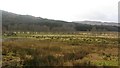
Damp grazing, Srath Ascaig
Flat land beneath steep forested hillsides.
Image: © Richard Webb
Taken: 14 Feb 2012
0.06 miles
2
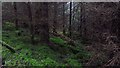
Dark woods
The next generation of spruce.
Image: © Richard Webb
Taken: 14 Feb 2012
0.13 miles
3
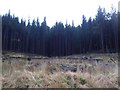
Sitka plantation, second time around
Commercial forestry dominates here, and this is a second generation of conifers. The gap in the trees
is shown as a track on the 1:25000 map, but is well and truly decommissioned, being little more than a
boggy ride.
Image: © Richard Webb
Taken: 14 Feb 2012
0.15 miles
4
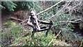
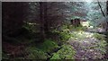
Carving
Wood carving found in the forest while looking for a way into NG8833.
Image: © Richard Webb
Taken: 14 Feb 2012
0.17 miles