IMAGES TAKEN NEAR TO
Forestry Houses, STROME FERRY, IV53 8UN
Introduction
This page details the photographs taken nearby to Forestry Houses, IV53 8UN by members of the Geograph project.
The Geograph project started in 2005 with the aim of publishing, organising and preserving representative images for every square kilometre of Great Britain, Ireland and the Isle of Man.

There are currently over 7.5m images from over14,400 individuals and you can help contribute to the project by visiting https://www.geograph.org.uk
Image Map (Loading...)


Getting Data...Please wait
Leaflet Map data © OpenStreetMap
Images are licensed for reuse under creativecommons.org/licenses/by-sa/2.0
Notes
- Clicking on the map will re-center to the selected point.
- The higher the marker number, the further away the image location is from the centre of the postcode.
Image Listing (27 Images Found)
Images are licensed for reuse under creativecommons.org/licenses/by-sa/2.0
Image
Details
Distance
6
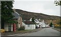
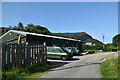
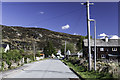
Achmore village street
Not much seems to happen here.
Image: © Gordon Hatton
Taken: 8 May 2023
0.05 miles
9
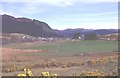
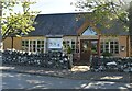
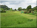
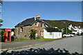
Achmore
Achmore is almost surrounded by forest plantations.
Image: © Anne Burgess
Taken: Unknown
0.08 miles