IMAGES TAKEN NEAR TO
Bornisketaig, Kilmuir, PORTREE, IV51 9YS
Introduction
This page details the photographs taken nearby to IV51 9YS by members of the Geograph project.
The Geograph project started in 2005 with the aim of publishing, organising and preserving representative images for every square kilometre of Great Britain, Ireland and the Isle of Man.

There are currently over 7.5m images from over14,400 individuals and you can help contribute to the project by visiting https://www.geograph.org.uk
Image Map
Images are licensed for reuse under creativecommons.org/licenses/by-sa/2.0
Notes
- Clicking on the map will re-center to the selected point.
- The higher the marker number, the further away the image location is from the centre of the postcode.
Image Listing (27 Images Found)
Images are licensed for reuse under creativecommons.org/licenses/by-sa/2.0
Image
Details
Distance
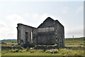
1
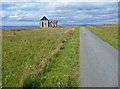
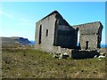
Ruined church in Bornesketaig
The church dates from 1810. It is shown intact on the 1903 OS map, but was documented as ruinous in 1961, so its demise was somewhere between those years.
Image: © John Allan
Taken: 17 Aug 2008
0.08 miles
2
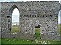
Church ruins
The wall on the west of the building, seen from what was the interior.
The church dates from 1810. It is shown intact on the 1903 OS map, but was documented as ruinous in 1961, so its demise was somewhere between those years.
Image: © John Allan
Taken: 17 Aug 2008
0.08 miles
3
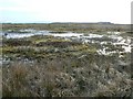
Boggy ground
Even after a fairly long dry spell, parts of the ground like this around Bornesketaig remain wet and boggy.
Image: © James Allan
Taken: 22 Apr 2008
0.08 miles
4
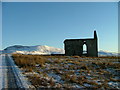
Ruined Chapel in Bornesketaig
With Suidh' a' Mhinn in the background.
Image: © Dave Fergusson
Taken: 8 Jan 2010
0.10 miles
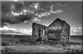
5
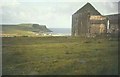
Dilapidated church
The stark remains of an abandoned church in Kilmuir parish, perched prominently above the little harbour of Camas Mor.
Image: © James Allan
Taken: 20 Apr 2008
0.10 miles
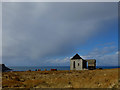
6
Ruined church, Bornesketaig in 1967
With the headland of Sgeir Lang and the bay of Camas Mor in the distance.
Image: © John Baker
Taken: 3 Sep 1967
0.11 miles
7
Cattle by the old church in Bornesketaig
With a view out across Camas Mor and the Minch.
Image: © John Allan
Taken: 22 Feb 2016
0.11 miles
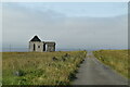
10
The former parish church of Kilmuir
Built in 1810 to replace its predecessor in Kilmaluaig, this church had a seating capacity of 700. It sits on open moorland, exposed to "all the airts the wind can blow".
The building material was landed at nearby Camus Mor, and it is said this site was selected to save the expense and effort of cartage.
It is referred to as "the present church" by William Mackenzie in his 1930 book, "Iochdar-Trotternish".
Image: © John Allan
Taken: 27 Nov 2012
0.12 miles