IMAGES TAKEN NEAR TO
Park Grove, PORTREE, IV51 9XR
Introduction
This page details the photographs taken nearby to Park Grove, IV51 9XR by members of the Geograph project.
The Geograph project started in 2005 with the aim of publishing, organising and preserving representative images for every square kilometre of Great Britain, Ireland and the Isle of Man.

There are currently over 7.5m images from over14,400 individuals and you can help contribute to the project by visiting https://www.geograph.org.uk
Image Map
Images are licensed for reuse under creativecommons.org/licenses/by-sa/2.0
Notes
- Clicking on the map will re-center to the selected point.
- The higher the marker number, the further away the image location is from the centre of the postcode.
Image Listing (77 Images Found)
Images are licensed for reuse under creativecommons.org/licenses/by-sa/2.0
Image
Details
Distance
1
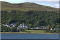
Bridge of Rha, Uig
From the Tarbert to Uig ferry.
Image: © Mike Pennington
Taken: 29 Jul 2011
0.03 miles
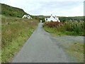
2
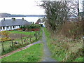
Footpath to Park Terrace
This footpath leads from the Staffin road. Uig bay is in the distance.
Image: © Dave Fergusson
Taken: 8 Dec 2009
0.04 miles
3
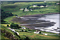
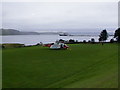
The head of Uig Bay
The hotel and church can be seen over the water.
Image: © Julian Paren
Taken: Unknown
0.05 miles
5
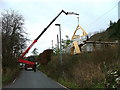
Road Block
A crane blocks the Staffin road as it hoists roof trusses up to a new build.
Image: © Dave Fergusson
Taken: 8 Dec 2009
0.06 miles
8
Stornoway Coastguard helicopter in Uig
The helicopter was called out to winch a paramedic on board the MV Hebrides as it approached Uig pier. A man had fallen overboard into Loch Snizort and had been picked up by the ferry's fast rescue launch. The MV Hebrides, now docked, can be seen in the distance.
Image: © Dave Fergusson
Taken: 11 Aug 2010
0.08 miles
9
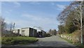
Boyd Terrace, Uig
This was the original single track road to the pier before the new A87 road was built, skirting the bay. This view is looking northeast.
Image: © Dave Fergusson
Taken: 23 Sep 2008
0.09 miles
10
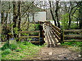
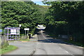
Footbridge over the River Rha
The bridge connects Uig playing fields to the community hall, seen in the picture. It was constructed in May 1988 by 124 (L) Royal Engineers (V). The stone to the left of the picture carries the plaque.
Image: © Dave Fergusson
Taken: 22 Apr 2010
0.10 miles