IMAGES TAKEN NEAR TO
Eyre, PORTREE, IV51 9XB
Introduction
This page details the photographs taken nearby to IV51 9XB by members of the Geograph project.
The Geograph project started in 2005 with the aim of publishing, organising and preserving representative images for every square kilometre of Great Britain, Ireland and the Isle of Man.

There are currently over 7.5m images from over14,400 individuals and you can help contribute to the project by visiting https://www.geograph.org.uk
Image Map
Images are licensed for reuse under creativecommons.org/licenses/by-sa/2.0
Notes
- Clicking on the map will re-center to the selected point.
- The higher the marker number, the further away the image location is from the centre of the postcode.
Image Listing (6 Images Found)
Images are licensed for reuse under creativecommons.org/licenses/by-sa/2.0
Image
Details
Distance
1
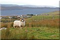
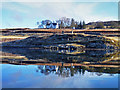
Blackface tup at Eyre
Standing proud on the rough grazing above Loch Snizort Beag.
Image: © John Allan
Taken: 9 Nov 2007
0.07 miles
4
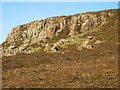
Cruinn Bheinn
A craggy outcrop on the summit above Kensaleyre.
Image: © John Allan
Taken: 25 Jan 2006
0.25 miles
5
Kensaleyre Old Manse
A listed building, dating from the early 19th century.
Image: © John Allan
Taken: 16 Mar 2013
0.25 miles
6
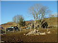
Dilapidated croft house at Eyre
Old cars are handy around some of the crofts, in this case, to store fertilizer and feed bags.
Image: © Dave Fergusson
Taken: 8 Mar 2010
0.25 miles