IMAGES TAKEN NEAR TO
Swordale, Broadford, ISLE OF SKYE, IV49 9AS
Introduction
This page details the photographs taken nearby to IV49 9AS by members of the Geograph project.
The Geograph project started in 2005 with the aim of publishing, organising and preserving representative images for every square kilometre of Great Britain, Ireland and the Isle of Man.

There are currently over 7.5m images from over14,400 individuals and you can help contribute to the project by visiting https://www.geograph.org.uk
Image Map (Loading...)


Getting Data...Please wait
Leaflet Map data © OpenStreetMap
Images are licensed for reuse under creativecommons.org/licenses/by-sa/2.0
Notes
- Clicking on the map will re-center to the selected point.
- The higher the marker number, the further away the image location is from the centre of the postcode.
Image Listing (21 Images Found)
Images are licensed for reuse under creativecommons.org/licenses/by-sa/2.0
Image
Details
Distance
1
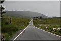
The B8083 west of Suardal
Obviously recently renewed, possibly in connection with timber extraction operations. The well known graveyard of Kilchrist (Cill Chriosd) can be seen in the distance.
Image: © Nigel Brown
Taken: 18 Jun 2009
0.03 miles
2
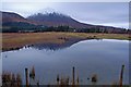
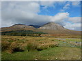
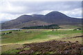
Flooded pasture by the Torrin road
A frequent occurrence here after rain. In the background is Beinn na Caillich with a dusting of snow.
Image: © John Allan
Taken: 10 Jan 2008
0.04 miles
3
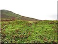
Old boundaries, Strath Suardal
Old grass covered dykes. Beinn Shuardail in the background.
Image: © Richard Webb
Taken: 20 Sep 2010
0.05 miles
4
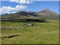
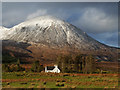
A drystone wall around a field at Suardal
With Beinn na Caillich beyond.
Image: © David Medcalf
Taken: 4 Jun 2022
0.08 miles
6
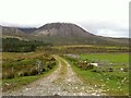
House in Suardal
Seen from the Marble Line Path, with Beinn na Caillich rising beyond it.
Image: © John Allan
Taken: 30 Nov 2015
0.11 miles
8
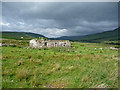
Old house in Suardal
A solitary house with a large, rectangular walled field behind it.
Image: © John Allan
Taken: 2 Jul 2010
0.11 miles
9
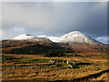
Strath Suardal
Evidence of historic human activity is revealed by climbing Beinn Shuardail. The red hills dominating the view are (left to right) Beinn Dearg Bheag, Beinn Dearg Mhòr and Beinn na Caillich.
Image: © Ian Taylor
Taken: 10 May 2022
0.12 miles
10
Gathering sheep in Strath Suardal
A crofter with a quadbike and two collies has just brought a small flock into the pens. The Broadford Red Hills are under fresh snow in the background.
Image: © John Allan
Taken: 30 Nov 2015
0.12 miles