IMAGES TAKEN NEAR TO
Cannich, BEAULY, IV4 7NA
Introduction
This page details the photographs taken nearby to IV4 7NA by members of the Geograph project.
The Geograph project started in 2005 with the aim of publishing, organising and preserving representative images for every square kilometre of Great Britain, Ireland and the Isle of Man.

There are currently over 7.5m images from over14,400 individuals and you can help contribute to the project by visiting https://www.geograph.org.uk
Image Map (Loading...)


Getting Data...Please wait
Leaflet Map data © OpenStreetMap
Images are licensed for reuse under creativecommons.org/licenses/by-sa/2.0
Notes
- Clicking on the map will re-center to the selected point.
- The higher the marker number, the further away the image location is from the centre of the postcode.
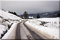
Image Listing (9 Images Found)
Images are licensed for reuse under creativecommons.org/licenses/by-sa/2.0
Image
Details
Distance
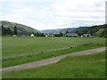
2
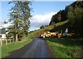
Approach to Kerrow Farm
Balnabruich Holidays sign.
Image: © Stanley Howe
Taken: 8 Oct 2009
0.05 miles

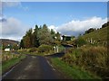
5
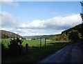
Minor road to Tomich
The houses visible are marked as the settlement called Kerrow.
Image: © Steven Brown
Taken: 15 Jan 2008
0.12 miles
9
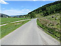
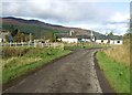
Minor road at the entrance to Balnabruich
Looking north-eastward.
Image: © Peter Wood
Taken: 31 May 2021
0.25 miles