IMAGES TAKEN NEAR TO
Ardendrain, Kiltarlity, BEAULY, IV4 7HS
Introduction
This page details the photographs taken nearby to IV4 7HS by members of the Geograph project.
The Geograph project started in 2005 with the aim of publishing, organising and preserving representative images for every square kilometre of Great Britain, Ireland and the Isle of Man.

There are currently over 7.5m images from over14,400 individuals and you can help contribute to the project by visiting https://www.geograph.org.uk
Image Map
Images are licensed for reuse under creativecommons.org/licenses/by-sa/2.0
Notes
- Clicking on the map will re-center to the selected point.
- The higher the marker number, the further away the image location is from the centre of the postcode.
Image Listing (13 Images Found)
Images are licensed for reuse under creativecommons.org/licenses/by-sa/2.0
Image
Details
Distance
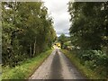
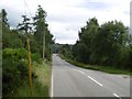
1
Minor road near to Ardendrain
Looking south-westward.
Image: © Peter Wood
Taken: 1 Jun 2021
0.03 miles
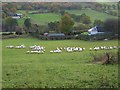
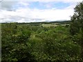
2
Looking across to Ardendrain from Convinth
Image: © Sarah McGuire
Taken: 13 Aug 2010
0.04 miles
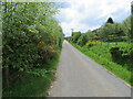
4
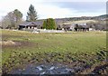
Glenview Chalet Park, Ardendrain
A small chalet park at Ardendrain, Kiltarlity. Good views over Glen Convinth from here.
Image: © Craig Wallace
Taken: 2 Feb 2013
0.13 miles
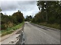
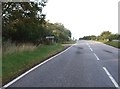
7
A833
Never steep, but it keeps on climbing. Looking downhill.
Image: © Richard Webb
Taken: 25 Jul 2016
0.19 miles
8
View over the Belladrum Burn
Patchwork of woods and pasture seen from the A833.
Image: © Richard Webb
Taken: 25 Jul 2016
0.20 miles
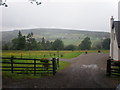
9

Field at Ardendrain
Looking towards the woods on Blue Bonnet Hill. They occupy much of this square.
Image: © John Allan
Taken: 18 Jul 2008
0.20 miles