IMAGES TAKEN NEAR TO
Fraser Court, BEAULY, IV4 7FR
Introduction
This page details the photographs taken nearby to Fraser Court, IV4 7FR by members of the Geograph project.
The Geograph project started in 2005 with the aim of publishing, organising and preserving representative images for every square kilometre of Great Britain, Ireland and the Isle of Man.

There are currently over 7.5m images from over14,400 individuals and you can help contribute to the project by visiting https://www.geograph.org.uk
Image Map
Images are licensed for reuse under creativecommons.org/licenses/by-sa/2.0
Notes
- Clicking on the map will re-center to the selected point.
- The higher the marker number, the further away the image location is from the centre of the postcode.
Image Listing (19 Images Found)
Images are licensed for reuse under creativecommons.org/licenses/by-sa/2.0
Image
Details
Distance
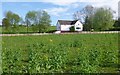
2
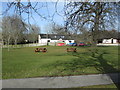
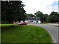
Bus stop, Kiltarlity
Beside a village green dominated by an impressive oak tree.
Image: © Mike Pennington
Taken: 9 Aug 2012
0.04 miles
3
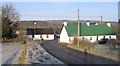
Kiltarlity Post Office
This is the Kiltarlity post office, village shop and coffee shop.
Previously this building was the village pub, The Allarburn Bar. In 2008 the pub closed and the post office moved here, from its previous location on Post Office Brae - Image
OS 1st and 2nd Edition 6 Inch maps (1872 and 1902) show a post office here, so it seems it has returned to its original location.
Image: © Craig Wallace
Taken: 16 Jan 2012
0.06 miles
4
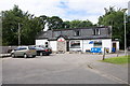
Kiltarlity shop and post office
The post office moved here from Post Office Brae a few years ago.
Image: © Mike Pennington
Taken: 9 Aug 2012
0.06 miles
5
Down Post Office Brae
Looking down Post Office Brae, a road on the outskirts of Kiltarlity village.
The white building on the left is the former post office and postmaster's house. In 2008 the post office moved into a larger premises a short distance away, see Image
This building is now just a house.
Image: © Craig Wallace
Taken: 16 Jan 2012
0.07 miles
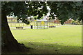
7
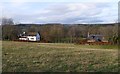
Fields and houses, by Post Office Brae
Looking west from Post Office Brae, towards a couple of houses on the edge of Kiltarlity village. The left house is Bruiach Mill, see Image
The Beauly-Denny Power Line is visible on the hills beyond. The snow topped Beinn a' Bhathach Àrd is in the distance to the left.
Image: © Craig Wallace
Taken: 1 Jan 2014
0.09 miles
8
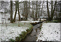
Allarburn / Aultfearn, Kiltarlity
The Allarburn or Aultfearn, meaning stream of the alder trees. A small stream passing though woodland, here it is crossed by a pipe.
Originally the main settlement in the area was known as Allarburn/Aultfearn, but is now usually referred to as Kiltarlity village.
Image: © Craig Wallace
Taken: 13 Jan 2021
0.10 miles
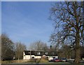
9
Bruiach Mill
Old OS maps have this marked as a corn mill, and show it was supplied by a system of mill lades, ponds and dams, taking water from the Bruiach Burn. A few parts of these dams remain visible, see Image
The building is now a private house.
Image: © Craig Wallace
Taken: 25 May 2013
0.12 miles
10
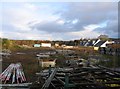
Site of the former Balgate Sawmill
The sawmill closed and was demolished a few years ago. The site is now being used for a housing development. The first houses were completed a month or so ago, they can be seen in the centre-right of the photo.
There are plans/proposals for quite a few more houses on the site.
Image: © Craig Wallace
Taken: 1 Dec 2011
0.16 miles