IMAGES TAKEN NEAR TO
BEAULY, IV4 7EY
Introduction
This page details the photographs taken nearby to IV4 7EY by members of the Geograph project.
The Geograph project started in 2005 with the aim of publishing, organising and preserving representative images for every square kilometre of Great Britain, Ireland and the Isle of Man.

There are currently over 7.5m images from over14,400 individuals and you can help contribute to the project by visiting https://www.geograph.org.uk
Image Map
Images are licensed for reuse under creativecommons.org/licenses/by-sa/2.0
Notes
- Clicking on the map will re-center to the selected point.
- The higher the marker number, the further away the image location is from the centre of the postcode.
Image Listing (8 Images Found)
Images are licensed for reuse under creativecommons.org/licenses/by-sa/2.0
Image
Details
Distance
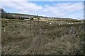
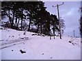
1

Minor road and sheep grazing near Beauly
Image: © Steven Brown
Taken: 9 Jan 2011
0.16 miles
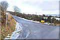
2
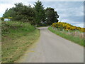
Minor road near to Ruisaurie
Looking north-eastward.
Image: © Peter Wood
Taken: 4 Jun 2021
0.17 miles
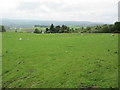
3
Pouncing fox near Ruisaurie Burn
The fox was trying to catch a mouse in a field on the west side of Ruisaurie Burn just above its junction with Red Burn. The burns flow down the steep brae in deep tree-filled ravines before joining and continuing along the edge of Teachnuick Wood. Part of Beauly can be seen through the trees.
Image: © Les Shaw
Taken: 31 Jan 2010
0.17 miles
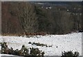
6
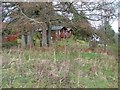
Wooden Chalets at Redburn
In Teachnuik Wood.
Image: © Dave Fergusson
Taken: 9 Mar 2007
0.20 miles