IMAGES TAKEN NEAR TO
BEAULY, IV4 7AA
Introduction
This page details the photographs taken nearby to IV4 7AA by members of the Geograph project.
The Geograph project started in 2005 with the aim of publishing, organising and preserving representative images for every square kilometre of Great Britain, Ireland and the Isle of Man.

There are currently over 7.5m images from over14,400 individuals and you can help contribute to the project by visiting https://www.geograph.org.uk
Image Map (Loading...)


Getting Data...Please wait
Leaflet Map data © OpenStreetMap
Images are licensed for reuse under creativecommons.org/licenses/by-sa/2.0
Notes
- Clicking on the map will re-center to the selected point.
- The higher the marker number, the further away the image location is from the centre of the postcode.
Image Listing (8 Images Found)
Images are licensed for reuse under creativecommons.org/licenses/by-sa/2.0
Image
Details
Distance
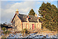
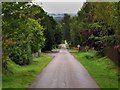
1
Cul-de-sac to Teanaluick
The Gaelic 'Tigh-an-luig' means house of the 'lag' or hollow but an alternative rendition might be Tean-an-tslic meaning 'bog-house'. Either way the hamlet referred to is beside a burn.
Image: © Stuart Logan
Taken: 4 Jun 2011
0.03 miles
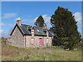
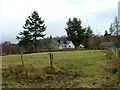
2
Woodland at Teandalloch
Southwest of Muir of Ord.
Image: © Dave Fergusson
Taken: 9 Mar 2007
0.09 miles
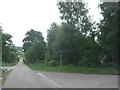
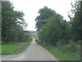
3
Country Lane by Muir of Ord Golf Course
Image: © Carol Bleasdale
Taken: 19 Sep 2010
0.14 miles
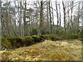
6
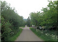
Road through Teandalloch
Teandalloch (Gaelic = Tigh an dalach) translates as 'house of the dale'.
Image: © Stuart Logan
Taken: 4 Jun 2011
0.20 miles