IMAGES TAKEN NEAR TO
Ardvasar, ISLE OF SKYE, IV45 8RP
Introduction
This page details the photographs taken nearby to IV45 8RP by members of the Geograph project.
The Geograph project started in 2005 with the aim of publishing, organising and preserving representative images for every square kilometre of Great Britain, Ireland and the Isle of Man.

There are currently over 7.5m images from over14,400 individuals and you can help contribute to the project by visiting https://www.geograph.org.uk
Image Map (Loading...)


Getting Data...Please wait
Leaflet Map data © OpenStreetMap
Images are licensed for reuse under creativecommons.org/licenses/by-sa/2.0
Notes
- Clicking on the map will re-center to the selected point.
- The higher the marker number, the further away the image location is from the centre of the postcode.
Image Listing (22 Images Found)
Images are licensed for reuse under creativecommons.org/licenses/by-sa/2.0
Image
Details
Distance
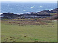
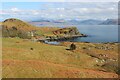
1
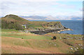
Tormore
On the headland to seaward of the house at Tormore is Dùn Chlò. A discontinuous grassy bank encloses a roughly circular area, 9-10m in diameter. Single outer facing stones on the SW arc. Two short stretches of outer walling to the SE on the seaward side.The dun is mentioned in the Statistical Account of 1795.
Image: © Anne Burgess
Taken: 1 May 2014
0.02 miles
2
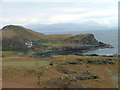
Tormore
Near the Aird of Sleat.A large house with extensive farm buildings.
Image: © Dave Fergusson
Taken: 15 Mar 2006
0.02 miles
3
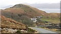
Tormore
House named after the hill behind it.
Image: © Richard Webb
Taken: 15 Feb 2012
0.03 miles
5
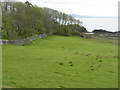
Pasture and woodland at Tormore
Looking out to the Sound of Sleat.
Image: © M J Richardson
Taken: 16 May 2013
0.06 miles
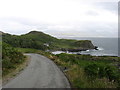
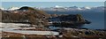
7
Coastline at Tormore
The view is across the Sound of Sleat to the mainland. The ferry crossings between Mallaig and Skye had been cancelled because of gale-force winds and high seas in the Sound.
Image: © John Allan
Taken: 3 Feb 2011
0.08 miles
8
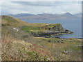
Tormore
Farmhouse and rocky headland, looking east out to the Sound of Sleat.
Image: © M J Richardson
Taken: 16 May 2013
0.09 miles
9
Tormore, Sleat
Mainland mountains beyond.
Image: © Alan Reid
Taken: 17 Apr 2023
0.12 miles
10
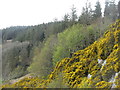
Gorse and forestry at Tormore
On the road to Aird /An Àird from Armadale/Armadail
Image: © M J Richardson
Taken: 16 May 2013
0.12 miles