IMAGES TAKEN NEAR TO
Ferrindonald, Teangue, ISLE OF SKYE, IV44 8RF
Introduction
This page details the photographs taken nearby to IV44 8RF by members of the Geograph project.
The Geograph project started in 2005 with the aim of publishing, organising and preserving representative images for every square kilometre of Great Britain, Ireland and the Isle of Man.

There are currently over 7.5m images from over14,400 individuals and you can help contribute to the project by visiting https://www.geograph.org.uk
Image Map
Images are licensed for reuse under creativecommons.org/licenses/by-sa/2.0
Notes
- Clicking on the map will re-center to the selected point.
- The higher the marker number, the further away the image location is from the centre of the postcode.
Image Listing (6 Images Found)
Images are licensed for reuse under creativecommons.org/licenses/by-sa/2.0
Image
Details
Distance
1
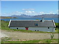
House With a View
Looking north east up the Sound of Sleat.
Image: © Dave Fergusson
Taken: 21 May 2006
0.05 miles
2
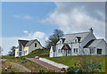
New houses in Ferindonald
Two new buildings, the one on the left incomplete, overlooking the Sound of Sleat.
Image: © John Allan
Taken: 17 Apr 2012
0.10 miles
3
House overlooking The Sound of Sleat
In the township of Ferindonald.
Image: © Dave Fergusson
Taken: 21 May 2006
0.17 miles
4
Ferindonald, Skye
Looking south-east over the Sound of Sleat towards Knoydart and North Morar.
Image: © Bob Jones
Taken: 24 May 2006
0.18 miles
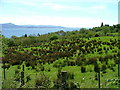
5
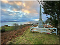
Sleat War Memorial
Located just north of the church in Kilmore, the monument lists the fallen men of Sleat in each of the two world wars of the twentieth century.
The water is the southern end of the Sound of Sleat, with the Scottish mainland beyond.
Image: © John Allan
Taken: 15 Dec 2020
0.22 miles
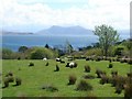
6
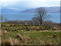
Rough grazings above the Sound of Sleat
Cattle are on this ground in Ferindonald. The view is to the Scottish mainland.
Image: © John Allan
Taken: 17 Apr 2012
0.23 miles