IMAGES TAKEN NEAR TO
Drumfearn, Isle Ornsay, ISLE OF SKYE, IV43 8QZ
Introduction
This page details the photographs taken nearby to IV43 8QZ by members of the Geograph project.
The Geograph project started in 2005 with the aim of publishing, organising and preserving representative images for every square kilometre of Great Britain, Ireland and the Isle of Man.

There are currently over 7.5m images from over14,400 individuals and you can help contribute to the project by visiting https://www.geograph.org.uk
Image Map (Loading...)


Getting Data...Please wait
Leaflet Map data © OpenStreetMap
Images are licensed for reuse under creativecommons.org/licenses/by-sa/2.0
Notes
- Clicking on the map will re-center to the selected point.
- The higher the marker number, the further away the image location is from the centre of the postcode.
Image Listing (4 Images Found)
Images are licensed for reuse under creativecommons.org/licenses/by-sa/2.0
Image
Details
Distance
2
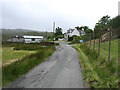
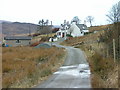
The lane to Drumfearn
Drumfearn is a tiny settlement at the north end of the Sleat peninsula.
Image: © David Purchase
Taken: 18 Jun 2018
0.08 miles
3
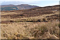
Moorland by the L?n Creadha
Looking over the rough ground south of Drumfearn.
The hill in the distance is Beinn na Seamraig, above Kinloch.
Image: © John Allan
Taken: 1 Mar 2011
0.20 miles
4
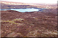
Mullach an Achaidh Mhoir
A wet and heathery hill of 101m near Drumfearn. A trig point is marked here on the OS 1:25k map. It appears nowhere else, on maps or in databases that I can find. Tramped up here just to check, but there is no sign of anything on the ground either. Odd.
The view is to the head of Loch Eishort.
Image: © John Allan
Taken: 3 Mar 2008
0.24 miles