IMAGES TAKEN NEAR TO
Croft Lane, INVERNESS, IV3 8UD
Introduction
This page details the photographs taken nearby to Croft Lane, IV3 8UD by members of the Geograph project.
The Geograph project started in 2005 with the aim of publishing, organising and preserving representative images for every square kilometre of Great Britain, Ireland and the Isle of Man.

There are currently over 7.5m images from over14,400 individuals and you can help contribute to the project by visiting https://www.geograph.org.uk
Image Map (Loading...)


Getting Data...Please wait
Leaflet Map data © OpenStreetMap
Images are licensed for reuse under creativecommons.org/licenses/by-sa/2.0
Notes
- Clicking on the map will re-center to the selected point.
- The higher the marker number, the further away the image location is from the centre of the postcode.
Image Listing (11 Images Found)
Images are licensed for reuse under creativecommons.org/licenses/by-sa/2.0
Image
Details
Distance
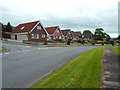
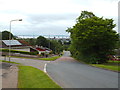
3
Kincraig Terrace, Inverness
Kincraig Terrace is a residential cul-de-sac in Inverness.
Image: © Malc McDonald
Taken: 22 Jun 2015
0.13 miles
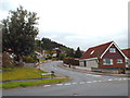
4
Scorguie Road, Inverness
Scorguie Road is a residential road in Inverness.
Image: © Malc McDonald
Taken: 22 Jun 2015
0.14 miles
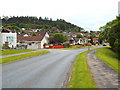
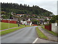
5
Scorguie Road, Inverness
Scorguie Road in Inverness. The Kessock Bridge, carrying the trunk A9 road north out of Inverness, is visible in the background.
Image: © Malc McDonald
Taken: 22 Jun 2015
0.15 miles
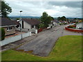
8
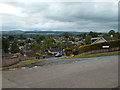
Kennedy Drive, Inverness
This cul-de-sac is a branch off Kennedy Drive.
Image: © Malc McDonald
Taken: 22 Jun 2015
0.20 miles
9
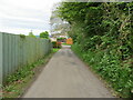
Narrow enclosed lane heading towards Woodside Crescent, Scorguie
Looking eastward.
Image: © Peter Wood
Taken: 4 Jun 2021
0.20 miles
10
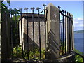
Clachnaharry Monument
Originally standing 40 to 50 feet high, this monument was erected in 1821 to commemorate a mediaeval battle between Clan Munro and Clan Chattan - the exact date of the battle is uncertain, though sources indicate that the clash took place sometime between 1333 and 1434. The tall column which originally stood on the base was blown down in a gale in 1951.
Image: © Euan Nelson
Taken: 29 Jul 2009
0.22 miles