IMAGES TAKEN NEAR TO
Bunchrew, INVERNESS, IV3 8RQ
Introduction
This page details the photographs taken nearby to IV3 8RQ by members of the Geograph project.
The Geograph project started in 2005 with the aim of publishing, organising and preserving representative images for every square kilometre of Great Britain, Ireland and the Isle of Man.

There are currently over 7.5m images from over14,400 individuals and you can help contribute to the project by visiting https://www.geograph.org.uk
Image Map
Images are licensed for reuse under creativecommons.org/licenses/by-sa/2.0
Notes
- Clicking on the map will re-center to the selected point.
- The higher the marker number, the further away the image location is from the centre of the postcode.
Image Listing (7 Images Found)
Images are licensed for reuse under creativecommons.org/licenses/by-sa/2.0
Image
Details
Distance
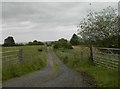
2
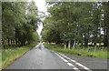
Minor road between Englishton Muir and Kirkton Muir
The road to the right leads to Kirkton Muir
Image: © Douglas Nelson
Taken: 17 Jul 2019
0.19 miles
3
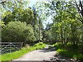
Track through the trees at Englishton Muir
Image: © Alpin Stewart
Taken: 5 Jun 2016
0.19 miles
4
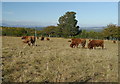
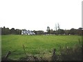
Cattle, by Englishton Muir
Just past the end of the road at Englishton Muir, this area is mostly fields, forestry and a few houses. Some cattle grazing in this rough field.
Image: © Craig Wallace
Taken: 16 Oct 2015
0.20 miles
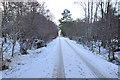
7
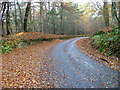
Road Through Englishton Muir Wood
A lovely mixed woodland.
Image: © Dave Fergusson
Taken: 11 Nov 2006
0.25 miles