IMAGES TAKEN NEAR TO
Cameron Road, INVERNESS, IV3 8PU
Introduction
This page details the photographs taken nearby to Cameron Road, IV3 8PU by members of the Geograph project.
The Geograph project started in 2005 with the aim of publishing, organising and preserving representative images for every square kilometre of Great Britain, Ireland and the Isle of Man.

There are currently over 7.5m images from over14,400 individuals and you can help contribute to the project by visiting https://www.geograph.org.uk
Image Map
Images are licensed for reuse under creativecommons.org/licenses/by-sa/2.0
Notes
- Clicking on the map will re-center to the selected point.
- The higher the marker number, the further away the image location is from the centre of the postcode.
Image Listing (95 Images Found)
Images are licensed for reuse under creativecommons.org/licenses/by-sa/2.0
Image
Details
Distance
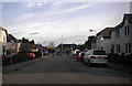
1
Balnacraig Lane, Inverness
A short road leading onto Telford Street that serves as access to some of the shops.
Image: © Mike Pennington
Taken: 21 Oct 2012
0.09 miles
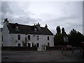
2
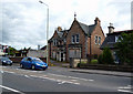
Inverness: Briton Lodge (Disused building) on the A862
This building, known as Briton Lodge, is known to have been in use in the 1970s as a workbase for the Inverness Community Nursing staff. There were two upstairs bedrooms used for short-term accommodation for visitors or new staff. The building was later sold, possibly to a religious organisation. Any other information on its later or earlier use/s would be welcome. I am indebted for the above to Malcolm MacLeod.
Image: © Dr Neil Clifton
Taken: 30 Jul 2012
0.09 miles
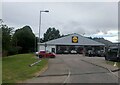
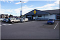
3
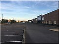
Carpark for retail units, Telford Street, Inverness
Image: © Steven Brown
Taken: 10 Sep 2022
0.10 miles
4
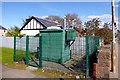
Air quality monitoring station, Telford Street
This green box is beside Telford Street (A862), next to a small path that links to Cameron Square. It doesn't have seem to have any signs on it saying what it is, just a warning of compressed gas.
It is actually an air quality monitoring station, part of the Automatic Urban and Rural Network (AURN). It measures nitric oxide, nitrogen dioxide and particulate matter, as well as the temperature and wind.
Site details on the Defra website: http://uk-air.defra.gov.uk/networks/aurn-site-info?site_id=INV2
Image: © Craig Wallace
Taken: 16 Apr 2012
0.10 miles
5
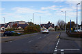
Dunain Road about to join Telford Street
Image: © Peter Bond
Taken: 14 Oct 2015
0.10 miles
9
Houses between Muirtown Basin quay and the A862 roundabout
Image: © Stanley Howe
Taken: 9 Oct 2009
0.14 miles
10
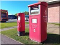
Postboxes at Inverness
IV3 116 & IV3 126P. Royal Mail list these boxes as 'Glendoe Terrace' & 'Glendoe Terrace (P)'.
Image: © David Bremner
Taken: 17 Oct 2023
0.14 miles