IMAGES TAKEN NEAR TO
INVERNESS, IV3 8JN
Introduction
This page details the photographs taken nearby to IV3 8JN by members of the Geograph project.
The Geograph project started in 2005 with the aim of publishing, organising and preserving representative images for every square kilometre of Great Britain, Ireland and the Isle of Man.

There are currently over 7.5m images from over14,400 individuals and you can help contribute to the project by visiting https://www.geograph.org.uk
Image Map
Images are licensed for reuse under creativecommons.org/licenses/by-sa/2.0
Notes
- Clicking on the map will re-center to the selected point.
- The higher the marker number, the further away the image location is from the centre of the postcode.
Image Listing (12 Images Found)
Images are licensed for reuse under creativecommons.org/licenses/by-sa/2.0
Image
Details
Distance
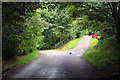
1
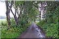
Minor road near Loch Ness Hotel
The dead-end road descends towards the Caledonian Canal and River Ness.
Image: © Richard Dorrell
Taken: 11 Aug 2019
0.06 miles
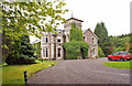
3
Dunain Hill
Dunain Hill in the background with Dunain Park Hotel in the foreground.
Image: © don cload
Taken: 15 Sep 2011
0.07 miles
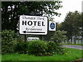
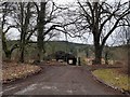
4
Loch Ness Country House Hotel
Formerly named Dunain Park Hotel, the house dates from 1800 and was refurbished in to its present state 2011.
It is Category C Listed.
Image: © Richard Dorrell
Taken: 11 Aug 2019
0.09 miles
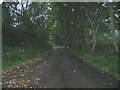
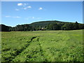
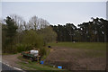
7

Field below Dulnain Park
Loch Ness Country House Hotel nestling in the trees
Image: © valenta
Taken: 15 Apr 2020
0.14 miles
9
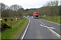
Inverness Tour Bus on the A82
Tour bus heading north, towards Inverness, on the A82.
Image: © David Dixon
Taken: 4 Apr 2017
0.20 miles
10
Highland : Grassy Field
A grassy field alongside the A38.
Image: © Lewis Clarke
Taken: 24 Apr 2016
0.22 miles