IMAGES TAKEN NEAR TO
Lochalsh Road, INVERNESS, IV3 8HP
Introduction
This page details the photographs taken nearby to Lochalsh Road, IV3 8HP by members of the Geograph project.
The Geograph project started in 2005 with the aim of publishing, organising and preserving representative images for every square kilometre of Great Britain, Ireland and the Isle of Man.

There are currently over 7.5m images from over14,400 individuals and you can help contribute to the project by visiting https://www.geograph.org.uk
Image Map (Loading...)


Getting Data...Please wait
Leaflet Map data © OpenStreetMap
Images are licensed for reuse under creativecommons.org/licenses/by-sa/2.0
Notes
- Clicking on the map will re-center to the selected point.
- The higher the marker number, the further away the image location is from the centre of the postcode.
Image Listing (85 Images Found)
Images are licensed for reuse under creativecommons.org/licenses/by-sa/2.0
Image
Details
Distance
1
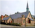
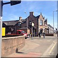
St Michael and All Angels Church
St Michael and All Angels Church at the corner of Abban Street and Lochalsh Road, Inverness, was built in 1886 on the other side of the River Ness from its present location. It was moved stone by stone with the roof being floated in sections on barges across the river in 1903/04. The interior was redesigned by Sir Ninian Comper in 1904 and 1926. A special feature is the stained glass window of the four Archangels by Comper.
Image: © Len Black
Taken: 21 Sep 2009
0.05 miles
3
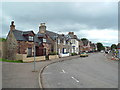
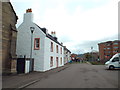
Abban Street, Inverness
Abban Street is not far from the centre of Inverness.
Image: © Malc McDonald
Taken: 22 Jun 2015
0.13 miles

8
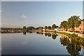
The River Ness, Inverness
View up-river along the River Ness on a clear morning in late summer. The bridge carries the A82 trunk road. The wall running along the River Bank is the Ness Flood Alleviation Scheme.
Image: © Andrew Tryon
Taken: 10 Sep 2016
0.15 miles
10
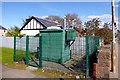
Air quality monitoring station, Telford Street
This green box is beside Telford Street (A862), next to a small path that links to Cameron Square. It doesn't have seem to have any signs on it saying what it is, just a warning of compressed gas.
It is actually an air quality monitoring station, part of the Automatic Urban and Rural Network (AURN). It measures nitric oxide, nitrogen dioxide and particulate matter, as well as the temperature and wind.
Site details on the Defra website: http://uk-air.defra.gov.uk/networks/aurn-site-info?site_id=INV2
Image: © Craig Wallace
Taken: 16 Apr 2012
0.16 miles